Raster Genie — Raster in FILE Columns, Queried in SQL and Asked in Plain English
An end-to-end example that lands Cloud Optimized GeoTIFFs (COGs) in FILE columns and queries them with the gbx_rst_* functions in plain SQL. It then asks a Genie Agent the same questions in plain English.
The notebook works one event: the 2024 Smokehouse Creek fire in the Texas Panhandle. It answers three questions from Sentinel-2 and WorldPop rasters: how much land burned, how severe it was, and how many people live there.
It takes the data through five steps:
- Land the incident perimeter, the counties it touches, Sentinel-2 scenes from before and after the fire, and WorldPop population.
- Stack each Sentinel-2 scene into one seven-band master COG, and register every COG in a
rasterstable through aFILE EXTERNALcolumn. Nothing is copied. - Query burn severity in SQL.
gbx_rst_fromfilereads only the COG blocks the perimeter needs.gbx_rst_nbrandgbx_rst_mapalgebrabuild the burn index.gbx_rst_histogramcounts the severity classes. - Map the severity classes over an Esri basemap.
- Ask two Genie Agents the same question and compare the SQL each one wrote and the time each one took.
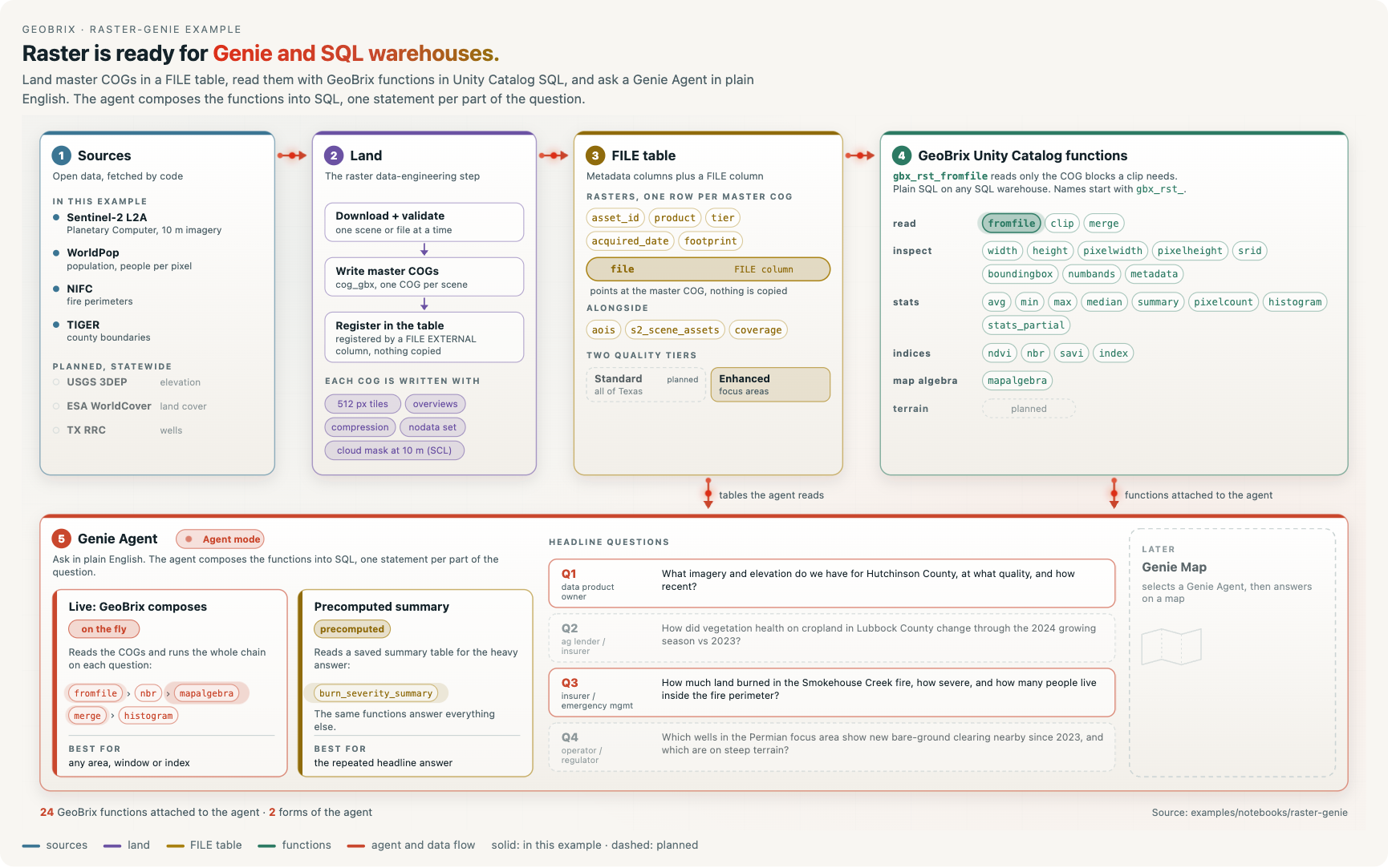
examples/notebooks/raster-genie — open the series from a Git folder, or download the whole folder, and import config_nb.ipynb and 01_smokehouse_creek.ipynb into your Databricks workspace to run.
genie/seed_agent.py creates two Genie Agents for the example. The live agent, below, answers from the four tables and composes the GeoBrix Unity Catalog raster functions itself, starting from gbx_rst_fromfile on the rasters FILE table.
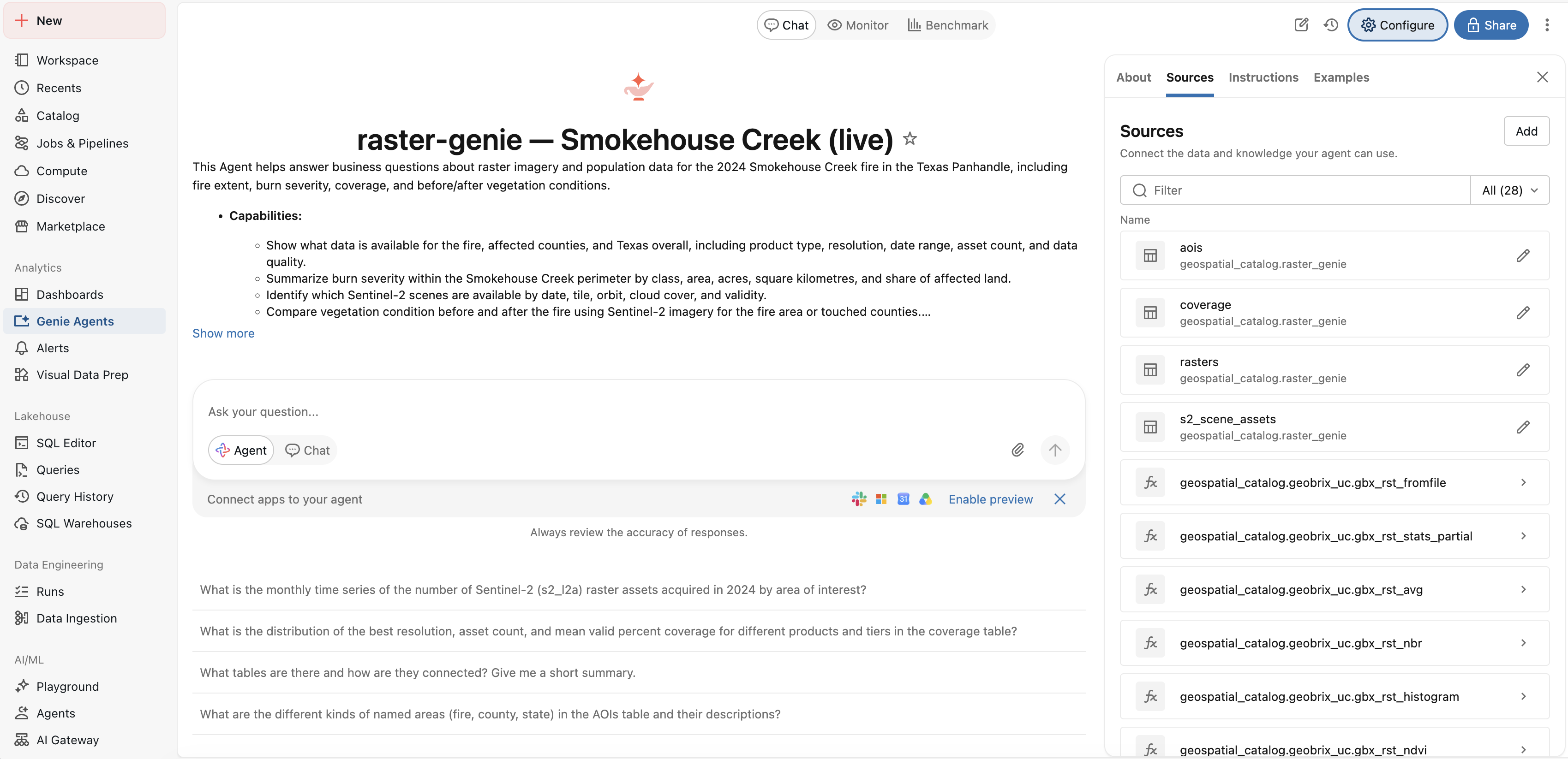
config_nb installs the geobrix[stac,vizx,databricks] env6 wheel, so the notebook runs on Serverless environment 6 with no JAR. The gbx_rst_* functions run in the session at the Python level. The same calls run in Unity Catalog once the GeoBrix Unity Catalog functions are installed. See Query FILE columns from Unity Catalog, Choose an install path and Surfaces & Levels.
Sentinel-2 L2A comes from Microsoft Planetary Computer through StacClient. The incident perimeter comes from NIFC WFIGS through FirePerimeterDownloader. Population comes from WorldPop through WorldPopDownloader. County and state boundaries come from the US Census TIGER cartographic files. The notebook fetches all of them over HTTPS, so it runs online only.
What the notebook shows
FILE columns and master COGs
Each Sentinel-2 scene becomes one seven-band master COG. The bands are B02, B03, B04, B08, B11, B12 and the scene classification layer (SCL). The COG has 512-pixel blocks, average overviews at 2, 4, 8 and 16, and nodata 0.
The scene is cloud-masked once, when the COG is written. SCL classes 0, 1, 3, 8, 9, 10 and 11 become nodata in the reflectance bands at 10 m. No query needs an SCL mask afterwards. SCL stays as band 7, valid at full resolution only.
The rasters table has one row per COG. Its FILE EXTERNAL column points at the COG on the Volume. The table is the catalog, and Unity Catalog opens the file under the caller's grants. The committed run holds 9 assets: 8 Sentinel-2 scenes (3.43 GB over about 32,885 km²) and 1 population COG.
Windowed reads and burn severity in SQL
gbx_rst_fromfile(file, 'GTiff', <perimeter>, 'EPSG:4326', <resolution>) reads only the COG blocks the perimeter needs, at a suitable overview. See Read a window of a raster file.
A Unity Catalog function can return at most 64 MiB. The notebook sizes the perimeter's window first. At 20 m the window is 306.5 MiB. The read steps up through the 40 m overview to the 80 m overview, where each window is 19.2 MiB.
One SQL statement turns a pre-fire and a post-fire scene of each tile into dNBR severity classes (Key and Benson, 2006; USGS):
- Pair each tile's pre and post scene, on the same relative orbit where possible.
- Index each read with
gbx_rst_nbr, then difference the pair withgbx_rst_mapalgebra. - Offset each tile's dNBR by the mean dNBR of its unburned reference ring, the band 1 to 5 km outside the perimeter.
- Classify into five classes, merge the tiles with
gbx_rst_merge, and count the pixels per class withgbx_rst_histogram.
The answer is saved as burn_severity_summary. WorldPop gives the people inside the perimeter, as the pixel mean times the count of valid pixels.
The Genie Agents
A Genie Agent is given the same tables, the gbx_rst_* functions and a short set of instructions. It writes the query itself from a plain-English question, in Agent mode. databricks.labs.gbx.genie builds the spaces and asks the question.
There are two agents over the same data and the same attached functions:
- The live agent computes the whole answer from the COGs, following the method its instructions teach.
- The precomputed agent reads the saved
burn_severity_summarytable for severity. It uses the functions for everything else, such as another area, resolution or statistic.
Both spaces hold rasters, aois, s2_scene_assets and coverage. The precomputed space also holds burn_severity_summary. Both attach 24 GeoBrix gbx_rst_* functions from geobrix_uc. The notebook prints each agent's SQL, answer and time.
Results in the committed run
The perimeter holds data over 1,053,900 acres. The burned total is the low, moderate-low, moderate-high and high classes together.
| Class | Severity | Acres | Share of valid pixels |
|---|---|---|---|
| 1 | Unburned | 421,906 | 40.0% |
| 2 | Low | 582,790 | 55.3% |
| 3 | Moderate-low | 46,779 | 4.4% |
| 4 | Moderate-high | 2,377 | 0.2% |
| 5 | High | 48 | 0.0% |
- Burned land: 631,994 acres at low severity or worse.
- People: about 3,849 inside the perimeter (WorldPop 2020). The count covers the whole perimeter, burned or not.
- Agents: the live agent answered in 151.8 s and the precomputed agent in 29.01 s. Both gave the same class table. They differ by one acre in the burned total, 631,993 against 631,994, from rounding.
These numbers come from one run. Read them with these points in mind:
- Winter grass and brush. The classes follow a table written for forest burns. A grass fire changes NBR far less than a forest fire, so most of this fire falls in the lower classes. The classes say more about relative severity than about absolute fuel loss.
- The offset. The ring offset removes the background difference between scene pairs. It cannot say which pair is nearer the truth, and it is only as good as the ring is unburned.
- Overlapping tiles. Where Sentinel-2 tiles overlap, a result depends on which tile's pixels win the merge.
gbx_rst_mergeapplies a fixed order, and the last tile in that order wins. For Hutchinson County, an independent check of the area at moderate-low or worse gives two results. It finds 3,841 acres with the tile that wins the merge, and 3,010 acres with the other tile. The effect on the perimeter totals has not been measured. - Population coverage. The population row of
coverageshows a valid percent below 1%. WorldPop's constrained grid is nodata wherever nobody lives, so most pixels of a rural window hold no value.
Files
| File | Purpose |
|---|---|
config_nb.ipynb | Shared setup, run with %run ./config_nb. It installs the env6 wheel, registers the functions with gbx.register(spark) and holds the user settings: catalog_name, schema_name, the fire, the pre and post windows, MAX_CLOUD, MAX_NODATA, BURN_RES_M, GENIE_SPACE_ID and GENIE_SPACE_ID_PRECOMPUTED. It creates the schema and a data Volume. |
01_smokehouse_creek.ipynb | The walk-through: aois, Sentinel-2 master COGs, WorldPop, the rasters FILE table, the coverage view, the burn severity query, a map and the Genie Agents. |
genie/agent_spec.py | The two Genie Agents: their tables, attached GeoBrix functions, instruction text and example SQL. |
genie/seed_agent.py | Creates or updates a Genie space from agent_spec and prints its id. Use --variant live or --variant precomputed. |
genie/run_questions.py | Asks one or both agents plain-language questions in Agent mode, several times each. It re-runs the agent's SQL on the warehouse, judges the rows and writes one row per run to evidence.json. |
lakeflow/land/scenes.py | stack_scene: per-band Sentinel-2 files in, one master COG out. It has unit tests in lakeflow/tests/. |
The notebook writes these tables to geospatial_catalog.raster_genie:
aois: the perimeter, the counties it touches and the Texas outline.s2_scene_assets: the Sentinel-2 scenes chosen.rasters: one row per master COG, with aFILE EXTERNALcolumn.coverage(view): what the series holds per product, tier and area.burn_severity_summary: the saved severity answer.
Prerequisites
- Serverless environment 6, or Databricks Runtime 19 (Python 3.12). The series needs no JAR.
- GeoBrix (version 0.6.0).
config_nbinstalls the env6 wheel from the Hub Volume. Change the path inconfig_nbif your staged wheel lives elsewhere. - The GeoBrix Unity Catalog functions, installed in your catalog, if you want to query
rastersfrom a SQL warehouse or Genie. The notebook itself calls the session functions. See Unity Catalog functions and the Unity Catalog SQL examples. - Unity Catalog permissions.
config_nbcreates the schema and a Volume nameddataif they are missing. You needCREATE SCHEMAandCREATE VOLUMEon the catalog. - The whole folder. Notebook 01 imports
stack_scenefromlakeflow/land/scenes.py. Open the series from a Git folder, or copylakeflow/next to the notebooks. - Genie spaces, for the last step only. The spaces need a SQL warehouse and the GeoBrix Unity Catalog functions in
geospatial_catalog.geobrix_uc. UntilGENIE_SPACE_IDis set, the Genie step prints a message and skips. The precomputed agent is skipped while its id is empty. - Network access to Planetary Computer, NIFC, WorldPop and Census.
Run order
- Open
config_nb.ipynb. Checkcatalog_nameandschema_name. Optionally setGENIE_SPACE_IDandGENIE_SPACE_ID_PRECOMPUTED. - Run
01_smokehouse_creek.ipynbtop to bottom. It starts with%run ./config_nb. - To ask the agents, create the two spaces with
genie/seed_agent.py(once per variant). Paste the ids it prints intoconfig_nb. Then rungenie/run_questions.pywith--space both.
The first run downloads the national WorldPop file once, about 0.5 GB, and the Sentinel-2 windows, a few GB. Every step is guarded: files already on the Volume are not downloaded again, and existing tables are not rewritten. A master COG written by an older stack_scene is rebuilt. Set FORCE_REBUILD = True in the cell right after %run ./config_nb to rebuild everything.
Run run_questions.py after the notebook, not during it. The notebook rewrites the tables the agents read. The script judges two of the questions against truth values recorded from one maintainer run. A different perimeter or scene pick needs refreshed truth values.
Data flow
NIFC WFIGS perimeter, Census TIGER counties            →  aois
Planetary Computer Sentinel-2 L2A (StacClient)         →  s2_scene_assets, band files
        │
        ▼  stack_scene: 7 bands, 512-px blocks, overviews, cloud-masked once
8 master COGs  +  1 WorldPop COG  (Volume)
        │
        ▼  FILE EXTERNAL column, nothing copied
rasters  ──▶  coverage (view)
        │
        ▼  gbx_rst_fromfile → gbx_rst_nbr → gbx_rst_mapalgebra → gbx_rst_merge → gbx_rst_histogram
burn_severity_summary  +  people inside the perimeter
        │
        ├─▶ severity map (vizx.plot_tile)
        └─▶ Genie Agents: live (from the COGs) and precomputed (from burn_severity_summary)
Key GeoBrix functions shown
gbx_rst_fromfilereads a window of a COG in a FILE column, clipped to a geometry and read at a chosen resolution.gbx_rst_nbr,gbx_rst_mapalgebra,gbx_rst_merge,gbx_rst_histogram,gbx_rst_avgandgbx_rst_pixelcountare RasterX functions. They build and count the severity classes and the population.StacClientsearches Planetary Computer and downloads windowed band files.FirePerimeterDownloaderandWorldPopDownloaderfetch the perimeter and the population grid.databricks.labs.gbx.geniebuilds a Genie space from tables, functions, instructions and example SQL, and asks it a question.vizx.plot_tiledraws the severity classes over a basemap.
For FILE columns see the File reader. For preparing master COGs see the COG writer and Large Rasters.