 Function Reference
RasterX functions run in two execution tiers — lightweight (pure-Python pyrx) and heavyweight (rasterx). As of v0.4.0, every RasterX function is available in both tiers (badged <Tier both/> per function below); per-function notes call out where the lightweight implementation differs. See Choosing an Execution Tier for the comparison and the lightweight install.
Complete reference for all RasterX functions with detailed descriptions, parameters, return values, and examples.
Overview
RasterX is GeoBrix's raster data processing package, providing comprehensive tools for working with raster datasets such as satellite imagery, elevation models, and other gridded spatial data. It is a refactor and improvement of Mosaic raster functions, extended in v0.4.0 with terrain analysis, spectral indices, vector-raster bridging, web-mercator tile output, and quadbin grid aggregations. Since the Databricks product does not (yet) support anything built-in specifically for raster processing, RasterX provides a gap-filling capability for raster operations on the Databricks platform.
Key Features
- GDAL-Powered: Leverages GDAL for robust raster format support
- Distributed Processing: Built on Spark for scalable raster operations
- Multiple Format Support: GeoTIFF, COG, NetCDF, and other GDAL-supported formats
- Metadata Extraction: Comprehensive raster metadata access
- Raster Operations: Clipping, resampling, transformations, map algebra
- Band Operations: Multi-band raster support, single-band extraction
- Terrain Analysis: Slope, aspect, hillshade, TRI, TPI, roughness, color-relief
- Spectral Indices: EVI, SAVI, NDWI, NBR, NDVI, plus a generic dispatcher
- Vector-Raster Bridge: Rasterize geometries, polygonize value regions
- Tile Publishing: Web-mercator XYZ tile generation (PNG / JPEG / WebP)
- Grid Aggregations: H3 and CARTO quadbin v0 cell aggregations
Function Categories
RasterX exposes 87+ SQL functions (registered as gbx_rst_*; available in Python and Scala as rst_*), organized into the following categories (see rasterx/functions.scala):
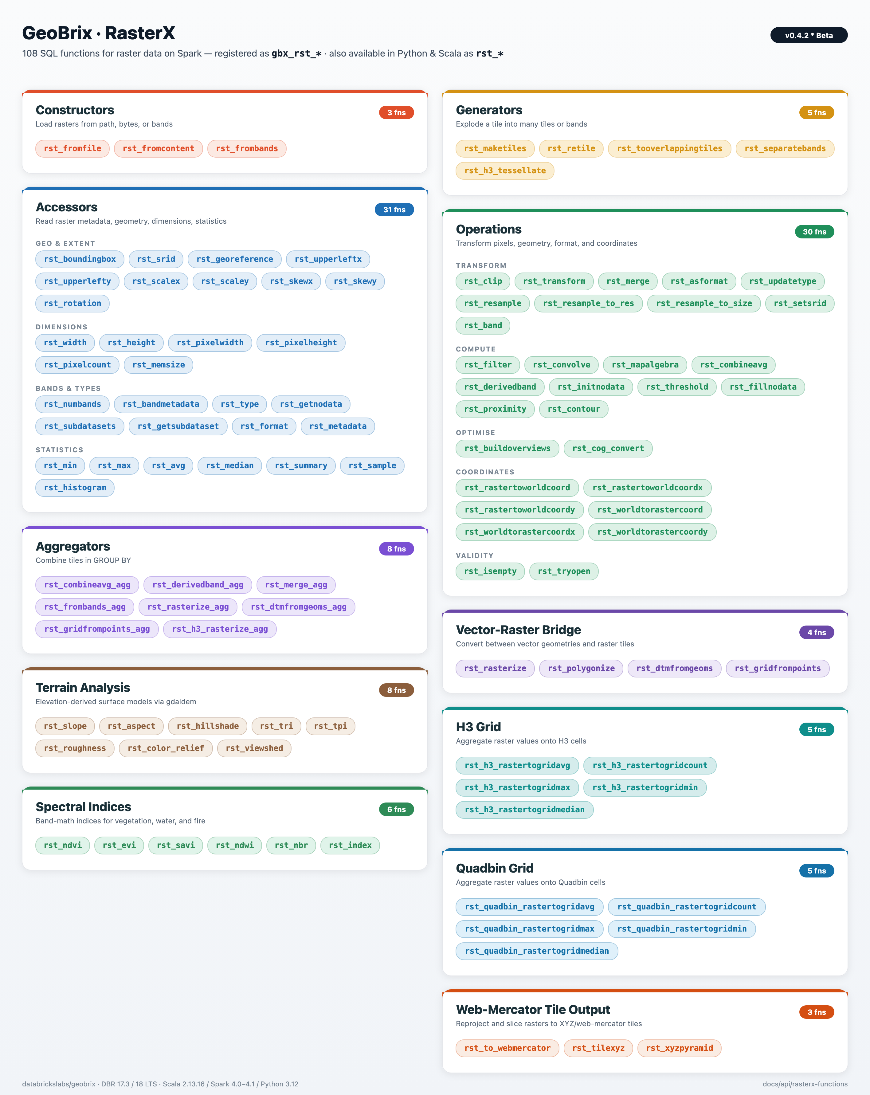
- Accessor Functions: Read raster properties and metadata (bounds, dimensions, CRS, bands, pixel size, georeference, format, type, NoData, subdatasets, summary, etc.)
- Aggregator Functions: Combine or merge rasters in group-by (combineavg_agg, derivedband_agg, merge_agg, h3_rasterize_agg)
- Constructor Functions: Create or load rasters from paths, binary content, or bands
- Generator Functions: Produce multiple tiles or bands (h3_tessellate, maketiles, retile, separatebands, tooverlappingtiles)
- Grid Functions (H3): Aggregate raster values to H3 cells (rastertogrid avg/count/max/min/median)
- Grid Functions (quadbin): Aggregate raster values to CARTO quadbin v0 cells (rastertogrid avg/count/max/min/median)
- Operations: Transform and analyze rasters (clip, transform, merge, asformat, ndvi, filter, convolve, map algebra, coordinate conversion, isEmpty, tryOpen, initNoData, updateType, combineavg, derivedband)
- Web-Mercator Tile Output: Reproject to EPSG:3857 and emit slippy-map XYZ tiles (to_webmercator, tilexyz, xyzpyramid)
- Vector-raster bridge: Burn polygons into rasters and trace contiguous regions back to polygons (rasterize, polygonize)
- Terrain Analysis: DEM-derived surfaces from
gdal.DEMProcessing(slope, aspect, hillshade, TRI, TPI, roughness, color relief) - Spectral Indices: Multi-band satellite math (EVI, SAVI, NDWI, NBR, plus the generic
rst_indexdispatcher)
Tile payload
Every RasterX function returns a tile whose raster field is a self-contained, in-memory raster (GTiff by default) — safe to serialize between Spark stages and executors, persist to Delta, hand off to rasterio / gdal, or write back out via the gdal writer. The bytes are never an XML reference to a per-executor /vsimem/ tempfile or to a path that only exists on the producing node.
Functions that internally build via an intermediate VRT — gbx_rst_merge, gbx_rst_merge_agg, gbx_rst_frombands, gbx_rst_combineavg, gbx_rst_combineavg_agg, gbx_rst_derivedband, gbx_rst_derivedband_agg — materialize the result to GTiff before returning, so downstream stages on different executors see real raster bytes. Inspect a tile's payload format from tile.metadata.driver; for any of the functions above, it will read GTiff (not VRT). See Beta Release Notes for the v0.3.0 correctness fix that introduced this invariant. See Tile structure for the full tile-struct schema.
Setup
Pick your execution tier and run this once. Both tiers alias the module as rx, so every example below is identical regardless of tier — only this setup differs. (See Choosing an Execution Tier for the comparison.)
- Lightweight (pyrx)
- Heavyweight (rasterx)
from pyspark.sql import functions as f
from databricks.labs.gbx.pyrx import functions as rx

# Build a 4 x 3, 2-band float32 GTiff in memory (origin 10.0, 50.0; 0.5 px; EPSG:4326).
raster_bytes = _make_geotiff_bytes(width=4, height=3, count=2, epsg=4326)

df = spark.createDataFrame([(raster_bytes,)], ["raster"])
tile_df = df.select(rx.rst_fromcontent("raster", f.lit("GTiff")).alias("tile"))
tile_df.createOrReplaceTempView("rasters")
One-row DataFrame with a tile column (struct<cellid, raster, metadata>).
Temp view `rasters` available for SQL examples.
from databricks.labs.gbx.rasterx import functions as rx
rx.register(spark)
rasters = spark.read.format("gdal").load(SAMPLE_RASTER_PATH)
rasters.createOrReplaceTempView("rasters")
RasterX registered. Temp view `rasters` created from sample raster.
After registering RasterX, create the SQL view so the SQL examples below can use FROM rasters:
-- After registering RasterX (Python: rx.register(spark)), create the view:
CREATE OR REPLACE TEMP VIEW rasters AS
SELECT * FROM gdal.`{SAMPLE_RASTER_PATH}`;
View `rasters` created. You can now run SELECT ... FROM rasters; for each example.
Usage Examples
Python/PySpark
These examples assume your tier is set up as in Setup above — imported as rx, registered (for the SQL examples), and a raster DataFrame (raster_df, with a tile column) loaded for your tier. The calls are identical in both tiers:
# Read raster properties off the `tile` column:
metadata_df = raster_df.select(
    rx.rst_width("tile").alias("width"),
    rx.rst_height("tile").alias("height"),
    rx.rst_numbands("tile").alias("bands"),
    rx.rst_srid("tile").alias("srid"),
)
metadata_df.show()
Scala
import com.databricks.labs.gbx.rasterx.{functions => rx}
import org.apache.spark.sql.functions._

// Register functions
rx.register(spark)

// Read raster files (sample data path; see Sample Data guide)
val rasterPath = "/Volumes/main/default/geobrix_samples/geobrix-examples/nyc/sentinel2/nyc_sentinel2_red.tif"
val rasterDf = spark.read.format("gdal").load(rasterPath)

// Get metadata
val metadataDf = rasterDf.select(
  col("path"),
  rx.rst_width(col("tile")).alias("width"),
  rx.rst_height(col("tile")).alias("height"),
  rx.rst_numbands(col("tile")).alias("num_bands")
)

metadataDf.show()
+--------------------+-----+------+----------+
|path                |width|height|num_bands |
+--------------------+-----+------+----------+
|.../nyc_sentinel2...|10980|10980 |1         |
+--------------------+-----+------+----------+
SQL
-- Register functions first in Python/Scala notebook
-- Then use in SQL

-- Read raster data (sample data path; see Sample Data guide)
CREATE OR REPLACE TEMP VIEW rasters AS
SELECT * FROM gdal.`{SAMPLE_RASTER_PATH}`;

-- Extract metadata
SELECT
    path,
    gbx_rst_width(tile) as width,
    gbx_rst_height(tile) as height,
    gbx_rst_numbands(tile) as num_bands,
    gbx_rst_srid(tile) as srid
FROM rasters;
+--------------------+-----+------+----------+----+
|path                |width|height|num_bands |srid|
+--------------------+-----+------+----------+----+
|.../nyc_sentinel2...|10980|10980 |1         |4326|
+--------------------+-----+------+----------+----+
Examples on this page use SQL, where RasterX functions are prefixed with gbx_ (e.g. gbx_rst_boundingbox, gbx_rst_width). For Python and Scala usage and more tips, see Language Bindings. In the lightweight tier, the registered gbx_rst_* SQL functions require every argument to be passed explicitly — optional defaults are honored only through the Python prx.* API.
Tier availability
As of v0.4.0, all RasterX functions run in both execution tiers — the lightweight pyrx (pure-Python) and heavyweight rasterx tiers share the same rst_* / gbx_rst_* names, and each function below carries a :::note Lightweight tier (pyrx) admonition with its backing library and any behavioral differences. For the heavyweight VRT Python pixel-function configuration (used by gbx_rst_combineavg / gbx_rst_derivedband), see VRT Python pixel functions at the end of this page.
Accessor Functions
Functions to read raster properties and metadata (29 total).
rst_avg
LightweightHeavyweightPowered by rasterio + NumPy. Per-band mean over valid (non-NoData) pixels.
Signature: rst_avg(tile: Column): Column — Per-band average pixel values.
Returns NULL for a band with zero valid pixels (all NoData) on both tiers.
SQL:
-- Get average values
SELECT
    path,
    gbx_rst_avg(tile) as band_averages,
    gbx_rst_avg(tile)[0] as band1_avg
FROM rasters;

-- Filter by average threshold
SELECT * FROM rasters
WHERE gbx_rst_avg(tile)[0] > 50.0;
+----+-------------+---------+
|path|band_averages|band1_avg|
+----+-------------+---------+
|... |[0.42]       |0.42     |
+----+-------------+---------+
rst_bandmetadata
LightweightHeavyweightPowered by rasterio.
Signature: rst_bandmetadata(tile: Column, band: Column): Column — Band metadata map.
SQL:
SELECT gbx_rst_bandmetadata(tile, 1) as band1_metadata FROM rasters;
+--------------+
|band1_metadata|
+--------------+
|{...}         |
+--------------+
rst_boundingbox
LightweightHeavyweightPowered by rasterio.
Signature: rst_boundingbox(tile: Column): Column — Bounding box geometry.
SQL:
SELECT path, gbx_rst_boundingbox(tile) as bbox FROM rasters;
+--------------------+-----------------+
|path                |bbox             |
+--------------------+-----------------+
|.../nyc_sentinel2...|POLYGON ((-74....|
+--------------------+-----------------+
rst_format
LightweightHeavyweightPowered by rasterio.
Signature: rst_format(tile: Column): Column — GDAL format name.
SQL:
-- Identify formats
SELECT
    gbx_rst_format(tile) as format,
    COUNT(*) as count
FROM rasters
GROUP BY gbx_rst_format(tile);

-- Find non-GeoTIFF files
SELECT path, gbx_rst_format(tile) as format
FROM rasters
WHERE gbx_rst_format(tile) != 'GTiff';
+------+-----+
|format|count|
+------+-----+
|GTiff |10   |
+------+-----+
rst_georeference
LightweightHeavyweightPowered by rasterio.
Signature: rst_georeference(tile: Column): Column — Georeference parameters as a map.
The result is a MapType with the following keys, corresponding to GDAL's 6-element geotransform:
| Key | Geotransform index | Meaning |
|---|---|---|
upperLeftX | GT(0) | X of the upper-left corner of the upper-left pixel |
upperLeftY | GT(3) | Y of the upper-left corner of the upper-left pixel |
scaleX | GT(1) | Pixel width (west–east resolution) |
scaleY | GT(5) | Pixel height (north–south resolution; often negative for north-up) |
skewX | GT(2) | Row rotation (typically 0) |
skewY | GT(4) | Column rotation (typically 0) |
See the GDAL geotransform tutorial and raster data model for details.
SQL:
SELECT gbx_rst_georeference(tile) as georeference FROM rasters;
+------------+
|georeference|
+------------+
|[ ... ]     |
+------------+
rst_getnodata
LightweightHeavyweightPowered by rasterio. Returns the dataset NoData value repeated once per band.
Signature: rst_getnodata(tile: Column): Column — NoData values per band.
SQL:
SELECT
    path,
    gbx_rst_getnodata(tile) as nodata_values,
    gbx_rst_getnodata(tile)[0] as band1_nodata
FROM rasters;
+----+-------------+------------+
|path|nodata_values|band1_nodata|
+----+-------------+------------+
|... |[-9999.0]    |-9999.0     |
+----+-------------+------------+
rst_getsubdataset
LightweightHeavyweightPowered by rasterio. Subdataset availability depends on rasterio's bundled GDAL driver set.
Signature: rst_getsubdataset(tile: Column, subsetName: Column): Column — Extract subdataset.
SQL:
SELECT
    path,
    gbx_rst_getsubdataset(tile, 'temperature') as temp_layer
FROM netcdf_files;
+----+----------------------------------------------+
|path|temp_layer                                    |
+----+----------------------------------------------+
|... |{null, <raster bytes>, {driver -> GTiff, ...}}|
+----+----------------------------------------------+
rst_height
LightweightHeavyweightPowered by rasterio.
Signature: rst_height(tile: Column): Column — Height in pixels.
SQL:
SELECT gbx_rst_height(tile) as height, gbx_rst_width(tile) as width FROM rasters;
+------+-----+
|height|width|
+------+-----+
|10980 |10980|
+------+-----+
rst_max
LightweightHeavyweightPowered by rasterio + NumPy. Per-band maximum over valid (non-NoData) pixels.
Signature: rst_max(tile: Column): Column — Maximum pixel values per band.
Returns NULL for a band with zero valid pixels (all NoData) on both tiers.
SQL:
SELECT path, gbx_rst_max(tile) as max_per_band, gbx_rst_max(tile)[0] as band1_max FROM rasters;
+----+------------+---------+
|path|max_per_band|band1_max|
+----+------------+---------+
|... |[255.0]     |255.0    |
+----+------------+---------+
rst_median
LightweightHeavyweightPowered by rasterio + NumPy. Per-band median over valid (non-NoData) pixels.
Signature: rst_median(tile: Column): Column — Median pixel values per band.
Returns NULL for a band with zero valid pixels (all NoData) on both tiers.
SQL:
SELECT
    path,
    gbx_rst_avg(tile)[0] as mean_value,
    gbx_rst_median(tile)[0] as median_value,
    ABS(gbx_rst_avg(tile)[0] - gbx_rst_median(tile)[0]) as skewness
FROM rasters;
+----+----------+------------+--------+
|path|mean_value|median_value|skewness|
+----+----------+------------+--------+
|... |0.45      |0.42        |0.03    |
+----+----------+------------+--------+
rst_memsize
LightweightHeavyweightPowered by rasterio. Returns the serialized raster size in bytes.
Signature: rst_memsize(tile: Column): Column — In-memory size in bytes.
SQL:
SELECT path, gbx_rst_memsize(tile) as size_bytes FROM rasters;
+----+----------+
|path|size_bytes|
+----+----------+
|... |120560400 |
+----+----------+
rst_metadata
LightweightHeavyweightPowered by rasterio.
Signature: rst_metadata(tile: Column): Column — Metadata map.
SQL:
SELECT gbx_rst_metadata(tile) as metadata FROM rasters;
+--------+
|metadata|
+--------+
|{...}   |
+--------+
rst_min
LightweightHeavyweightPowered by rasterio + NumPy. Per-band minimum over valid (non-NoData) pixels.
Signature: rst_min(tile: Column): Column — Minimum pixel values per band.
Returns NULL for a band with zero valid pixels (all NoData) on both tiers.
SQL:
SELECT path, gbx_rst_min(tile) as min_per_band, gbx_rst_min(tile)[0] as band1_min FROM rasters;
+----+------------+---------+
|path|min_per_band|band1_min|
+----+------------+---------+
|... |[0.0]       |0.0      |
+----+------------+---------+
rst_numbands
LightweightHeavyweightPowered by rasterio.
Signature: rst_numbands(tile: Column): Column — Number of bands.
SQL:
SELECT gbx_rst_numbands(tile) as bands FROM rasters;
+-----+
|bands|
+-----+
|1    |
+-----+
rst_pixelcount
LightweightHeavyweightPowered by rasterio + NumPy. Per-band count of valid (non-NoData) pixels.
Signature: rst_pixelcount(tile: Column): Column — Total pixel count.
SQL:
SELECT gbx_rst_pixelcount(tile) as pixel_count FROM rasters;
+-----------+
|pixel_count|
+-----------+
|120560400  |
+-----------+
rst_pixelheight
LightweightHeavyweightPowered by rasterio.
Signature: rst_pixelheight(tile: Column): Column — Pixel height in ground units.
SQL:
SELECT
    path,
    gbx_rst_pixelwidth(tile) as pixel_width,
    gbx_rst_pixelheight(tile) as pixel_height,
    gbx_rst_width(tile) * gbx_rst_pixelwidth(tile) as total_width_m
FROM rasters;
+----+-----------+------------+-------------+
|path|pixel_width|pixel_height|total_width_m|
+----+-----------+------------+-------------+
|... |30.0       |-30.0       |329400.0     |
+----+-----------+------------+-------------+
rst_pixelwidth
LightweightHeavyweightPowered by rasterio.
Signature: rst_pixelwidth(tile: Column): Column — Pixel width in ground units.
SQL:
SELECT
    path,
    gbx_rst_pixelwidth(tile) as pixel_width,
    gbx_rst_pixelheight(tile) as pixel_height,
    gbx_rst_width(tile) * gbx_rst_pixelwidth(tile) as total_width_m
FROM rasters;
+----+-----------+------------+-------------+
|path|pixel_width|pixel_height|total_width_m|
+----+-----------+------------+-------------+
|... |30.0       |-30.0       |329400.0     |
+----+-----------+------------+-------------+
rst_rotation
LightweightHeavyweightPowered by rasterio.
Signature: rst_rotation(tile: Column): Column — Rotation in radians.
SQL:
SELECT path, gbx_rst_rotation(tile) as rotation_rad FROM rasters;
+----+------------+
|path|rotation_rad|
+----+------------+
|... |0.0         |
+----+------------+
rst_scalex / rst_scaley
LightweightHeavyweightPowered by rasterio.
Signature: rst_scalex(tile: Column): Column, rst_scaley(tile: Column): Column — Scale (pixel size) in X/Y.
SQL:
SELECT
    path,
    gbx_rst_scalex(tile) as scale_x,
    gbx_rst_scaley(tile) as scale_y
FROM rasters;
+----+-------+-------+
|path|scale_x|scale_y|
+----+-------+-------+
|... |30.0   |-30.0  |
+----+-------+-------+
rst_skewx / rst_skewy
LightweightHeavyweightPowered by rasterio.
Signature: rst_skewx(tile: Column): Column, rst_skewy(tile: Column): Column — Skew in X/Y.
SQL:
SELECT
    path,
    gbx_rst_skewx(tile) as skew_x,
    gbx_rst_skewy(tile) as skew_y
FROM rasters;
+----+------+------+
|path|skew_x|skew_y|
+----+------+------+
|... |0.0   |0.0   |
+----+------+------+
rst_srid
LightweightHeavyweightPowered by rasterio.
Signature: rst_srid(tile: Column): Column — Spatial reference ID (e.g. EPSG).
SQL:
SELECT gbx_rst_srid(tile) as srid FROM rasters;
+-----+
|srid |
+-----+
|32618|
+-----+
rst_subdatasets
LightweightHeavyweightPowered by rasterio. Empty for single-dataset rasters (e.g. a plain GeoTIFF).
Signature: rst_subdatasets(tile: Column): Column — List of subdataset names.
SQL:
SELECT path, gbx_rst_subdatasets(tile) as subdatasets FROM netcdf_rasters;
+----+-------------------+
|path|subdatasets        |
+----+-------------------+
|... |[temp, precip, ...]|
+----+-------------------+
rst_summary
LightweightHeavyweightPowered by rasterio + NumPy. Returns a JSON summary (driver, size, CRS, geotransform, per-band statistics); the lightweight JSON shape differs from the heavyweight gdalinfo -json output.
Signature: rst_summary(tile: Column): Column — Statistical summary of values.
SQL:
SELECT path, gbx_rst_summary(tile) as summary FROM rasters;
+----+-------+
|path|summary|
+----+-------+
|... |{...}  |
+----+-------+
rst_type
LightweightHeavyweightPowered by rasterio.
Signature: rst_type(tile: Column): Column — Data type per band.
SQL:
-- Get data types
SELECT
    path,
    gbx_rst_type(tile) as band_types,
    gbx_rst_type(tile)[0] as band1_type
FROM rasters;

-- Group by data type
SELECT
    gbx_rst_type(tile)[0] as data_type,
    COUNT(*) as count
FROM rasters
GROUP BY gbx_rst_type(tile)[0];
+----+----------+----------+
|path|band_types|band1_type|
+----+----------+----------+
|... |[Byte]    |Byte      |
+----+----------+----------+
rst_upperleftx / rst_upperlefty
LightweightHeavyweightPowered by rasterio.
Signature: rst_upperleftx(tile: Column): Column, rst_upperlefty(tile: Column): Column — Upper-left corner coordinates.
SQL:
SELECT
    path,
    gbx_rst_upperleftx(tile) as upper_left_x,
    gbx_rst_upperlefty(tile) as upper_left_y
FROM rasters;
+----+------------+------------+
|path|upper_left_x|upper_left_y|
+----+------------+------------+
|... |500000.0    |200000.0    |
+----+------------+------------+
rst_width
LightweightHeavyweightPowered by rasterio.
Signature: rst_width(tile: Column): Column — Width in pixels.
SQL:
SELECT gbx_rst_width(tile) as width FROM rasters;
+-----+
|width|
+-----+
|10980|
+-----+
Aggregator Functions
Combine or merge rasters in group-by (7 total).
rst_combineavg_agg
LightweightHeavyweight Grouped-agg UDFPowered by rasterio + NumPy. Aggregate — groupBy(...).agg(rx.rst_combineavg_agg("tile")) returns the NoData-aware per-pixel mean as one tile per group; input tiles must share the same grid (shape/extent/CRS).
Heavyweight gbx_rst_combineavg_agg returns a tile STRUCT<cellid, raster, metadata>; the lightweight SQL function returns BINARY (the raster bytes). A PySpark grouped-aggregate pandas_udf cannot return a StructType, so the lightweight SQL aggregate returns the raster payload as BINARY. The lightweight Python wrapper rx.rst_combineavg_agg(...) returns the full tile struct (it composes the aggregate with a tile-wrapping step), so only raw SQL differs. To rebuild the tile-struct equivalent in SQL, select the group key as cellid and wrap the BINARY with gbx_rst_fromcontent:
-- Lightweight SQL: rebuild the (cellid, raster) the heavyweight struct would carry
SELECT
  group_key AS cellid,
  gbx_rst_fromcontent(gbx_rst_combineavg_agg(tile), 'GTiff') AS tile
FROM tiles
GROUP BY group_key
Signature: rst_combineavg_agg(tile: Column): Column — Average tiles per group.
SQL:
-- Group by region and average
SELECT
    region,
    gbx_rst_combineavg_agg(tile) as regional_average
FROM rasters
GROUP BY region;
+------+----------------------------------------------+
|region|regional_average                              |
+------+----------------------------------------------+
|...   |{null, <raster bytes>, {driver -> GTiff, ...}}|
+------+----------------------------------------------+
rst_derivedband_agg
LightweightHeavyweight Grouped-agg UDFPowered by rasterio with GDAL VRT Python pixel functions. Aggregate — groupBy(...).agg(rx.rst_derivedband_agg("tile", pyfunc, funcName)) stacks the group's tiles as bands and applies your pixel function, returning one tile per group.
Heavyweight gbx_rst_derivedband_agg returns a tile STRUCT<cellid, raster, metadata>; the lightweight SQL function returns BINARY (the raster bytes). A PySpark grouped-aggregate pandas_udf cannot return a StructType, so the lightweight SQL aggregate returns the raster payload as BINARY. The lightweight Python wrapper rx.rst_derivedband_agg(...) returns the full tile struct (it composes the aggregate with a tile-wrapping step), so only raw SQL differs. To rebuild the tile-struct equivalent in SQL, select the group key as cellid and wrap the BINARY with gbx_rst_fromcontent:
-- Lightweight SQL: rebuild the (cellid, raster) the heavyweight struct would carry
SELECT
  group_key AS cellid,
  gbx_rst_fromcontent(gbx_rst_derivedband_agg(tile, 'def f(a,b): return a+b', 'f'), 'GTiff') AS tile
FROM tiles
GROUP BY group_key
Signature: rst_derivedband_agg(tile: Column, pyfunc: String, funcName: String): Column — Apply Python UDF to tiles per group.
SQL:
SELECT region, gbx_rst_derivedband_agg(tile, 'def f(a): return a', 'f') as result FROM rasters GROUP BY region;
+------+----------------------------------------------+
|region|result                                        |
+------+----------------------------------------------+
|...   |{null, <raster bytes>, {driver -> GTiff, ...}}|
+------+----------------------------------------------+
rst_dtmfromgeoms_agg
LightweightHeavyweight Grouped-agg UDFPowered by rasterio + SciPy (scipy.spatial.Delaunay). Aggregate — builds one TIN DTM tile per group from the group's Z-valued points via barycentric interpolation over an unconstrained Delaunay triangulation; breaklines, merge_tolerance, and snap_tolerance are accepted but not enforced (the heavyweight tier builds a constrained TIN).
Heavyweight gbx_rst_dtmfromgeoms_agg returns a tile STRUCT<cellid, raster, metadata>; the lightweight SQL function returns BINARY (the raster bytes). A PySpark grouped-aggregate pandas_udf cannot return a StructType, so the lightweight SQL aggregate returns the raster payload as BINARY. The lightweight Python wrapper rx.rst_dtmfromgeoms_agg(...) returns the full tile struct (it composes the aggregate with a tile-wrapping step), so only raw SQL differs. To rebuild the tile-struct equivalent in SQL, select the group key as cellid and wrap the BINARY with gbx_rst_fromcontent:
-- Lightweight SQL: rebuild the (cellid, raster) the heavyweight struct would carry
SELECT
  group_key AS cellid,
  gbx_rst_fromcontent(
    gbx_rst_dtmfromgeoms_agg(point, null, 0.0, 0.0, 0,0,10,10, 8,8, 32633),
    'GTiff'
  ) AS tile
FROM observations
GROUP BY group_key
Streaming aggregator that accepts one Z-valued point WKB per row and produces a TIN/Delaunay DTM raster tile per group; breaklines are supplied as a per-group constant array to enforce hard terrain edges.
Signature: rst_dtmfromgeoms_agg(point: Column, breaklines: Column, mergeTolerance: Column, snapTolerance: Column, xmin: Column, ymin: Column, xmax: Column, ymax: Column, width: Column, height: Column, srid: Column): Column
Parameters: point — WKB point geometry with Z coordinate (one per row); breaklines — constant WKB array of breakline geometries per group (pass null or empty array if unused); remaining parameters match rst_dtmfromgeoms
SQL:
-- Stream survey points per region into one TIN DTM tile. Breaklines are a
-- per-group constant array; for 10 m cells over a 1000 m extent use 100 px.
SELECT region_id,
    gbx_rst_dtmfromgeoms_agg(
        point_wkb, breaklines_wkb_array,
        0.0, 0.01,
        bbox_xmin, bbox_ymin, bbox_xmax, bbox_ymax,
        100, 100, 32633
    ) AS dtm
FROM survey_points
GROUP BY region_id;
+---------+----------------------------------------------+
|region_id|dtm                                           |
+---------+----------------------------------------------+
|R-01     |{null, <raster bytes>, {driver -> GTiff, ...}}|
+---------+----------------------------------------------+
rst_frombands_agg
LightweightHeavyweight Grouped-agg UDFPowered by rasterio. Aggregate — groupBy(...).agg(rx.rst_frombands_agg("tile", "band_index")) stacks the group's tiles into one multi-band tile ordered by ascending band_index.
Heavyweight gbx_rst_frombands_agg returns a tile STRUCT<cellid, raster, metadata>; the lightweight SQL function returns BINARY (the raster bytes). A PySpark grouped-aggregate pandas_udf cannot return a StructType, so the lightweight SQL aggregate returns the raster payload as BINARY. The lightweight Python wrapper rx.rst_frombands_agg(...) returns the full tile struct (it composes the aggregate with a tile-wrapping step), so only raw SQL differs. To rebuild the tile-struct equivalent in SQL, select the group key as cellid and wrap the BINARY with gbx_rst_fromcontent:
-- Lightweight SQL: rebuild the (cellid, raster) the heavyweight struct would carry
SELECT
  group_key AS cellid,
  gbx_rst_fromcontent(gbx_rst_frombands_agg(tile, band_index), 'GTiff') AS tile
FROM bands
GROUP BY group_key
Streaming aggregator that collects ordered per-band tiles (one row per band) into a single multi-band raster tile per group; use when bands arrive as separate rows rather than a pre-built array.
Signature: rst_frombands_agg(tile: Column, bandIndex: Column): Column
Parameters: tile — Single-band raster tile; bandIndex — 1-based band position within the output raster
SQL:
-- Collect per-band tiles in acquisition order into one multi-band raster per scene.
SELECT scene_id,
    gbx_rst_frombands_agg(tile, band_index) AS multi_band
FROM band_tiles
GROUP BY scene_id;
+--------+----------------------------------------------+
|scene_id|multi_band                                    |
+--------+----------------------------------------------+
|S2A_001 |{null, <raster bytes>, {driver -> GTiff, ...}}|
+--------+----------------------------------------------+
rst_merge_agg
LightweightHeavyweight Grouped-agg UDFPowered by rasterio (rasterio.merge). Aggregate — groupBy(...).agg(rx.rst_merge_agg("tile")) merges the group's tiles into one mosaic tile (output spans the union extent).
Heavyweight gbx_rst_merge_agg returns a tile STRUCT<cellid, raster, metadata>; the lightweight SQL function returns BINARY (the raster bytes). A PySpark grouped-aggregate pandas_udf cannot return a StructType, so the lightweight SQL aggregate returns the raster payload as BINARY. The lightweight Python wrapper rx.rst_merge_agg(...) returns the full tile struct (it composes the aggregate with a tile-wrapping step), so only raw SQL differs. To rebuild the tile-struct equivalent in SQL, select the group key as cellid and wrap the BINARY with gbx_rst_fromcontent:
-- Lightweight SQL: rebuild the (cellid, raster) the heavyweight struct would carry
SELECT
  group_key AS cellid,
  gbx_rst_fromcontent(gbx_rst_merge_agg(tile), 'GTiff') AS tile
FROM tiles
GROUP BY group_key
Signature: rst_merge_agg(tile: Column): Column — Merge tiles per group.
SQL:
SELECT
    scene_id,
    gbx_rst_merge_agg(tile) as merged_scene
FROM satellite_tiles
GROUP BY scene_id;
+--------+----------------------------------------------+
|scene_id|merged_scene                                  |
+--------+----------------------------------------------+
|S2A_001 |{null, <raster bytes>, {driver -> GTiff, ...}}|
+--------+----------------------------------------------+
rst_rasterize_agg
LightweightHeavyweight Grouped-agg UDFPowered by rasterio (rasterio.features). Aggregate — burns the group's (geom, value) rows into one tile over the given extent/size/SRID (last-wins on overlap).
Heavyweight gbx_rst_rasterize_agg returns a tile STRUCT<cellid, raster, metadata>; the lightweight SQL function returns BINARY (the raster bytes). A PySpark grouped-aggregate pandas_udf cannot return a StructType, so the lightweight SQL aggregate returns the raster payload as BINARY. The lightweight Python wrapper rx.rst_rasterize_agg(...) returns the full tile struct (it composes the aggregate with a tile-wrapping step), so only raw SQL differs. To rebuild the tile-struct equivalent in SQL, select the group key as cellid and wrap the BINARY with gbx_rst_fromcontent:
-- Lightweight SQL: rebuild the (cellid, raster) the heavyweight struct would carry
SELECT
  group_key AS cellid,
  gbx_rst_fromcontent(
    gbx_rst_rasterize_agg(geom, value, 0,0,10,10, 8,8, 32633),
    'GTiff'
  ) AS tile
FROM features
GROUP BY group_key
Streaming aggregator that burns geometry/value pairs (one row per feature) into a single rasterized tile per group; use when features arrive as individual rows rather than as a pre-built collection.
Signature: rst_rasterize_agg(geom: Column, value: Column, xmin: Column, ymin: Column, xmax: Column, ymax: Column, width: Column, height: Column, srid: Column): Column
Parameters: geom — WKB geometry to burn; value — numeric burn value; xmin/ymin/xmax/ymax — output extent (in the target CRS); width/height — output raster dimensions in pixels; srid — EPSG code for the output CRS
SQL:
-- Aggregate per-feature burn values into one rasterized tile per region.
SELECT region_id,
    gbx_rst_rasterize_agg(
        geom_wkb, burn_value,
        bbox_xmin, bbox_ymin, bbox_xmax, bbox_ymax,
        256, 256, 4326
    ) AS tile
FROM features
GROUP BY region_id;
+---------+----------------------------------------------+
|region_id|tile                                          |
+---------+----------------------------------------------+
|R-01     |{null, <raster bytes>, {driver -> GTiff, ...}}|
+---------+----------------------------------------------+
rst_gridfrompoints_agg
LightweightHeavyweight Grouped-agg UDFPowered by rasterio + SciPy (cKDTree IDW). Aggregate — groupBy(...).agg(rx.rst_gridfrompoints_agg(...)) inverse-distance-interpolates the group's points into one Float64 grid tile (NoData −9999).
Heavyweight gbx_rst_gridfrompoints_agg returns a tile STRUCT<cellid, raster, metadata>; the lightweight SQL function returns BINARY (the raster bytes). A PySpark grouped-aggregate pandas_udf cannot return a StructType, so the lightweight SQL aggregate returns the raster payload as BINARY. The lightweight Python wrapper rx.rst_gridfrompoints_agg(...) returns the full tile struct (it composes the aggregate with a tile-wrapping step), so only raw SQL differs. To rebuild the tile-struct equivalent in SQL, select the group key as cellid and wrap the BINARY with gbx_rst_fromcontent:
-- Lightweight SQL: rebuild the (cellid, raster) the heavyweight struct would carry
SELECT
  group_key AS cellid,
  gbx_rst_fromcontent(
    gbx_rst_gridfrompoints_agg(point, value, 0,0,10,10, 8,8, 32633, 2.0, 12),
    'GTiff'
  ) AS tile
FROM observations
GROUP BY group_key
Streaming IDW-interpolation aggregator that accepts one point geometry and one scalar value per row and produces a Float64 GeoTIFF tile per group; use when observations arrive one per row rather than as pre-built arrays.
Signature: rst_gridfrompoints_agg(point: Column, value: Column, xmin: Column, ymin: Column, xmax: Column, ymax: Column, widthPx: Column, heightPx: Column, srid: Column, power: Column, maxPts: Column): Column
Parameters: point — WKB point geometry (one per row); value — scalar observation for the point; xmin/ymin/xmax/ymax — output extent in CRS units (constant per group); widthPx/heightPx — output dimensions in pixels; srid — EPSG code; power — IDW distance-decay exponent (2.0 is standard); maxPts — maximum nearest neighbours considered per output pixel
SQL:
-- Aggregate per-station observations into one IDW tile per region.
SELECT region_id,
    gbx_rst_gridfrompoints_agg(
        station_wkb, observation,
        bbox_xmin, bbox_ymin, bbox_xmax, bbox_ymax,
        256, 256, 32633
    ) AS idw
FROM observations
GROUP BY region_id;
+---------+----------------------------------------------+
|region_id|idw                                           |
+---------+----------------------------------------------+
|R-01     |{null, <raster bytes>, {driver -> GTiff, ...}}|
+---------+----------------------------------------------+
rst_h3_rasterize_agg
LightweightHeavyweight Grouped-agg UDFPowered by rasterio + h3. Aggregate — groupBy(...).agg(rx.rst_h3_rasterize_agg("cellid", "value", ...)) burns each H3 cell's centroid pixel (or spatial-envelope pixels with mode='spatial_envelope') into one raster tile per group. When value is omitted or null, all burned pixels carry 1.0 (presence mask). The extent and pixel size are derived automatically from the H3 resolution unless explicit bounds are supplied; kring_pad (default 1) expands the canvas by that many rings to avoid clipping edge cells.
Heavyweight gbx_rst_h3_rasterize_agg returns a tile STRUCT<cellid, raster, metadata>; the lightweight SQL function returns BINARY (the raster bytes). A PySpark grouped-aggregate pandas_udf cannot return a StructType, so the lightweight SQL aggregate returns the raster payload as BINARY. The lightweight Python wrapper rx.rst_h3_rasterize_agg(...) returns the full tile struct (it composes the aggregate with a tile-wrapping step), so only raw SQL differs. To rebuild the tile-struct equivalent in SQL, select the group key as cellid and wrap the BINARY with gbx_rst_fromcontent:
-- Lightweight SQL: rebuild the (cellid, raster) the heavyweight struct would carry
SELECT
  region_id AS cellid,
  gbx_rst_fromcontent(
    gbx_rst_h3_rasterize_agg(cellid, burn_value, 4326, null, null,null,null,null, null,null, 'centroids', 1),
    'GTiff'
  ) AS tile
FROM h3_cell_values
GROUP BY region_id
Streaming aggregator that burns H3 cell centroid pixels (or spatial-envelope pixels) into one raster tile per group. This is the inverse of rst_h3_rastertogrid*: where those functions reduce raster pixels to per-cell statistics, rst_h3_rasterize_agg reconstructs a raster from per-cell values. Use rst_frombands_agg to stack per-threshold rasters (each produced by one rst_h3_rasterize_agg call) into a single multi-band output.
The H3 Rasterize notebook walks this through end to end on a San Francisco Bay Area DEM: elevation isobands → H3 polyfill → a shared canvas from rst_h3_gridspec → per-band rst_h3_rasterize_agg → multi-band stack via rst_frombands_agg, visualized with the gbx.vizx helpers. The same pattern maps directly to a telco multi-threshold signal-coverage stack.
Signature: rst_h3_rasterize_agg(cellid: Column, value: Column, srid: Column, pixel_size: Column, xmin: Column, ymin: Column, xmax: Column, ymax: Column, width: Column, height: Column, mode: Column, kring_pad: Column): Column
Parameters:
cellid— H3 cell ID (BIGINT or STRING) to burn (one per row)value— numeric burn value; passnullfor a presence mask (all pixels →1.0)srid— EPSG code for the output CRS; defaults to4326(WGS 84)pixel_size— ground resolution in CRS units (derives from H3 resolution whennull)xmin/ymin/xmax/ymax— output canvas extent; auto-computed from cell bounds +kring_padwhennullwidth/height— output raster dimensions in pixels; auto-derived from extent + pixel_size whennullmode—'centroids'(default, burns the cell-centroid pixel only) or'spatial_envelope'(burns all pixels inside the hexagon envelope)kring_pad— ring count by which to expand the auto-computed canvas (default1)
SQL:
-- Rasterize H3 cells into one raster tile per region. Each cell's value is
-- burned at the cell centroid pixel. The output BINARY is a GTiff-encoded tile;
-- wrap with gbx_rst_fromcontent(..., 'GTiff') to recover a tile struct.
SELECT region_id,
    gbx_rst_h3_rasterize_agg(
        cellid, burn_value,
        4326, cast(null as double),
        cast(null as double), cast(null as double),
        cast(null as double), cast(null as double),
        cast(null as int), cast(null as int),
        'centroids', cast(1 as int)
    ) AS tile
FROM h3_cell_values
GROUP BY region_id;
+---------+----------------------------------------------+
|region_id|tile                                          |
+---------+----------------------------------------------+
|R-01     |{null, <raster bytes>, {driver -> GTiff, ...}}|
+---------+----------------------------------------------+
Constructor Functions
Create or load rasters from path, binary content, or bands (4 total).
rst_fromfile
Lightweightrst_fromfile is a convenience for pulling columnar raster paths into a tile column inline. To ingest rasters as a normal Spark job — partitioned parallel reads, optional tiling (sizeInMB), and FUSE-safe Volume staging — use the Raster Reader (raster_gbx / gtiff_gbx, or heavyweight gdal / gtiff_gdal): spark.read.format("raster_gbx").load(path).
Powered by rasterio. Opens the raster at path and re-encodes it as a GeoTIFF tile; the driver arg is a format hint (rasterio auto-detects on open). A missing/unreadable path returns null. Requires geobrix[light].
gbx_rst_fromfile has no heavyweight (JVM) implementation. On Databricks the executor JVM cannot read a Unity Catalog Volume (/Volumes/...) FUSE path — the UC credential is held only by Spark's managed Python worker — so the function is registered as a Python UDF even when you call it from SQL. With geobrix[light] installed it is available in SQL (SELECT gbx_rst_fromfile(...)) and in Python (rx.rst_fromfile(...)); without [light] it is not registered, and the Python binding raises with guidance.
Load a raster from a file path.
Signature: rst_fromfile(path: Column, driver: Column): Column
Parameters: path — File path; driver — GDAL driver name (e.g. GTiff)
Returns: Binary raster tile data
SQL:
-- Load from path
SELECT
    gbx_rst_fromfile('/data/raster.tif', 'GTiff') as tile;

-- Load multiple and get properties
SELECT
    path,
    gbx_rst_width(gbx_rst_fromfile(path, 'GTiff')) as width,
    gbx_rst_height(gbx_rst_fromfile(path, 'GTiff')) as height
FROM raster_paths;
+----------------------------------------------+
|tile                                          |
+----------------------------------------------+
|{null, <raster bytes>, {driver -> GTiff, ...}}|
+----------------------------------------------+

+----+-----+------+
|path|width|height|
+----+-----+------+
|... |10980|10980 |
+----+-----+------+
binaryFile + rst_fromcontentIf geobrix[light] is not installed, or you want a tier-agnostic path that works on any compute, read the bytes with Spark's built-in binaryFile reader and build the tile from content. This reads /Volumes reliably (the reader runs in Spark, which holds the credential) and works in both tiers:
df = (
    spark.read.format("binaryFile")
    .load("/Volumes/main/geobrix_samples/geobrix-examples/nyc/*.tif")
    .selectExpr("path", "gbx_rst_fromcontent(content, 'GTiff') AS tile")
)
SELECT path, gbx_rst_fromcontent(content, 'GTiff') AS tile
FROM read_files('/Volumes/main/geobrix_samples/geobrix-examples/nyc/', format => 'binaryFile')
rst_fromcontent
LightweightHeavyweightPowered by rasterio. The driver defaults to GTiff when unspecified and outputs are re-encoded as GeoTIFF; readable input formats are limited to the GDAL build bundled with rasterio.
Create a raster from binary content.
Signature: rst_fromcontent(content: Column, driver: Column): Column
Parameters: content — Binary column; driver — GDAL driver name
Returns: Binary raster tile data
SQL:
-- Load from binary table
SELECT
    path,
    gbx_rst_fromcontent(content, 'GTiff') as tile
FROM binary_raster_table;
+----+----------------------------------------------+
|path|tile                                          |
+----+----------------------------------------------+
|... |{null, <raster bytes>, {driver -> GTiff, ...}}|
+----+----------------------------------------------+
rst_dtmfromgeoms
LightweightHeavyweightPowered by rasterio + SciPy (scipy.spatial.Delaunay). Barycentric interpolation over an unconstrained Delaunay TIN; cells outside the convex hull are NoData. breaklines, merge_tolerance, and snap_tolerance are accepted for signature parity but not enforced — the heavyweight tier builds a constrained TIN that honors them.
Create a DTM raster tile via TIN/Delaunay interpolation from an array of Z-valued point WKB geometries, with an optional array of breakline WKB geometries to preserve sharp terrain transitions.
Signature: rst_dtmfromgeoms(points: Column, breaklines: Column, mergeTolerance: Column, snapTolerance: Column, xmin: Column, ymin: Column, xmax: Column, ymax: Column, width: Column, height: Column, srid: Column): Column
Parameters: points — Array of WKB point geometries with Z coordinates; breaklines — Array of WKB line/polygon geometries enforcing hard edges (pass null or empty array if unused); mergeTolerance/snapTolerance — Delaunay triangulation tolerances (vertex-merge distance and snapping distance; small values such as 0.0 and 0.01 are typical); xmin/ymin/xmax/ymax — output extent in CRS units; width/height — output raster dimensions in pixels (for N-metre cells set width = round((xmax-xmin)/N)); srid — EPSG code for the output CRS. An optional trailing noData argument overrides the default fill for cells outside the triangulated hull.
SQL:
-- TIN interpolation from arrays of Z-valued point WKB and breakline WKB.
-- Output is a 100 x 100 Float64 GTiff over the extent. For N-metre cells set
-- width_px = round((xmax-xmin)/N): here a 1000 m extent at 10 m cells -> 100 px.
SELECT gbx_rst_dtmfromgeoms(
    points_wkb_array, breaklines_wkb_array,
    0.0, 0.01,
    0.0, 0.0, 1000.0, 1000.0,
    100, 100, 32633
) AS dtm
FROM survey_points;
+----------------------------------------------+
|dtm                                           |
+----------------------------------------------+
|{null, <raster bytes>, {driver -> GTiff, ...}}|
+----------------------------------------------+
rst_frombands
LightweightHeavyweightPowered by rasterio. Stacks an ARRAY of single-band tiles into one multi-band tile in array order (element 0 → band 1), preserving georeference/CRS/dtype/NoData from the first.
Create a raster from an array of band tiles.
Signature: rst_frombands(bands: Column): Column
SQL:
SELECT
    gbx_rst_frombands(array(band1, band2, band3)) as multi_band
FROM separated_bands;
+----------------------------------------------+
|multi_band                                    |
+----------------------------------------------+
|{null, <raster bytes>, {driver -> GTiff, ...}}|
+----------------------------------------------+
rst_gridfrompoints
LightweightHeavyweightPowered by rasterio + SciPy (cKDTree IDW). Inverse-distance interpolation (power, max_pts) to a single-band Float64 grid; NoData −9999. Matches the heavyweight invdist defaults (power=2.0, max_pts=12).
IDW-interpolate an array of Z-valued point geometries to a Float64 GeoTIFF tile covering an explicit bounding box and pixel grid. Supply the points and their scalar values as arrays in a single row; use rst_gridfrompoints_agg when points arrive one per row.
Signature: rst_gridfrompoints(points: Column, values: Column, xmin: Column, ymin: Column, xmax: Column, ymax: Column, widthPx: Column, heightPx: Column, srid: Column, power: Column, maxPts: Column): Column
Parameters: points — ARRAY<BINARY> of WKB point geometries; values — ARRAY<DOUBLE> of scalar observations, one per point; xmin/ymin/xmax/ymax — output extent in CRS units; widthPx/heightPx — output dimensions in pixels; srid — EPSG code; power — IDW distance-decay exponent (2.0 is the standard); maxPts — maximum nearest neighbours considered per output pixel
SQL:
-- IDW (power=2, max_points=12) from arrays of point WKB and values.
-- Output is a 256 x 256 Float64 GTiff covering the requested extent.
SELECT gbx_rst_gridfrompoints(
    points_wkb_array, values_array,
    0.0, 0.0, 1000.0, 1000.0,
    256, 256, 32633
) AS idw
FROM point_clouds;
+----------------------------------------------+
|idw                                           |
+----------------------------------------------+
|{null, <raster bytes>, {driver -> GTiff, ...}}|
+----------------------------------------------+
Generator Functions
Produce multiple tiles or bands (5 total).
rst_h3_tessellate
LightweightHeavyweight Streaming UDTFPowered by rasterio + h3. Clips the raster to each overlapping H3 cell at resolution, returning one row per cell via streaming UDTF (matches the heavyweight generator behavior).
Signature: rst_h3_tessellate(tile: Column, resolution: Column, mode: Column = "covering"): Column — Tessellate raster to H3 cells. mode is "covering" (default — every overlapping cell, clipped) or "centroid" (pixel-centroid single-assignment partition). See H3 Raster Tessellation for the full mode guide.
SQL:
-- covering mode (default): every overlapping H3 cell, clipped to its hexagon
SELECT t.*
FROM rasters,
LATERAL gbx_rst_h3_tessellate(tile, 7, 'covering') t;

-- centroid mode: pixel-centroid single-assignment partition (no double-count)
SELECT t.*
FROM rasters,
LATERAL gbx_rst_h3_tessellate(tile, 7, 'centroid') t;

-- backward-compatible two-argument form (covering)
SELECT t.*
FROM rasters,
LATERAL gbx_rst_h3_tessellate(tile, 7) t;
+------+------------------+--------------+
|source|cellid            |raster        |
+------+------------------+--------------+
|...   |599686042433355775|<raster bytes>|
+------+------------------+--------------+
rst_maketiles
LightweightHeavyweight Streaming UDTFPowered by rasterio. Streams one tile row per subdivided region via streaming UDTF. It derives a square tile size from the MB budget and always partitions; it does not honor the heavyweight size_in_mb = -1 (single tile) or 0 (64 MB) sentinels or the power-of-four split, so tile counts and dimensions differ.
Signature: rst_maketiles(tile: Column, tileWidth: Column, tileHeight: Column): Column — Subdivide into smaller tiles.
SQL:
-- Subdivide and explode tiles
SELECT
    path,
    tile_subtile as tile
FROM rasters
LATERAL VIEW explode(gbx_rst_maketiles(tile, 512, 512)) AS tile_subtile;

-- Count tiles per raster
SELECT
    path,
    SIZE(gbx_rst_maketiles(tile, 512, 512)) as num_tiles
FROM rasters;
+----+----------------------------------------------+
|path|tile                                          |
+----+----------------------------------------------+
|... |{null, <raster bytes>, {driver -> GTiff, ...}}|
+----+----------------------------------------------+

+----+---------+
|path|num_tiles|
+----+---------+
|... |42       |
+----+---------+
rst_retile
LightweightHeavyweight Streaming UDTFPowered by rasterio. Streams one tile row per retiled region via streaming UDTF (matches the heavyweight generator behavior).
Signature: rst_retile(tile: Column, tileWidth: Column, tileHeight: Column): Column — Retile to uniform dimensions.
SQL:
SELECT
    path,
    tile
FROM rasters
LATERAL VIEW explode(gbx_rst_retile(tile, 256, 256)) AS tile;
+----+----------------------------------------------+
|path|tile                                          |
+----+----------------------------------------------+
|... |{null, <raster bytes>, {driver -> GTiff, ...}}|
+----+----------------------------------------------+
rst_separatebands
LightweightHeavyweight Streaming UDTFPowered by rasterio. Streams one band-tile row per band via streaming UDTF — O(1) worker memory regardless of band count (matches the heavyweight generator behavior).
Signature: rst_separatebands(tile: Column): Column — Split multi-band into array of bands.
SQL:
SELECT
    path,
    bands[0] as red_band,
    bands[1] as green_band,
    bands[2] as blue_band
FROM (
    SELECT path, gbx_rst_separatebands(tile) as bands
    FROM rgb_rasters
);
+----+----------------------------------------------+----------------------------------------------+----------------------------------------------+
|path|red_band                                      |green_band                                    |blue_band                                     |
+----+----------------------------------------------+----------------------------------------------+----------------------------------------------+
|... |{null, <raster bytes>, {driver -> GTiff, ...}}|{null, <raster bytes>, {driver -> GTiff, ...}}|{null, <raster bytes>, {driver -> GTiff, ...}}|
+----+----------------------------------------------+----------------------------------------------+----------------------------------------------+
rst_tooverlappingtiles
LightweightHeavyweight Streaming UDTFPowered by rasterio. Streams one tile row per overlapping region via streaming UDTF (matches the heavyweight generator behavior).
Signature: rst_tooverlappingtiles(tile: Column, tileWidth: Column, tileHeight: Column, overlap: Column): Column — Create overlapping tiles.
SQL:
SELECT
    path,
    tile
FROM rasters
LATERAL VIEW explode(gbx_rst_tooverlappingtiles(tile, 256, 256, 10)) AS tile;
+----+----------------------------------------------+
|path|tile                                          |
+----+----------------------------------------------+
|... |{null, <raster bytes>, {driver -> GTiff, ...}}|
+----+----------------------------------------------+
Grid Functions (H3)
Aggregate raster values to H3 grid cells, and utility functions for H3-based canvas setup (7 total).
rst_h3_rastertogridavg
LightweightHeavyweight Streaming UDTFPowered by rasterio + h3. Returns an ARRAY (one element per band) of ARRAY<struct(cellID, measure)>. The raster is interpreted as EPSG:4326 lon/lat — reproject upstream with rst_transform if your source CRS differs.
Signature: rst_h3_rastertogridavg(tile: Column, resolution: Column): Column
SQL:
-- Aggregate raster to H3 grid
SELECT
    path,
    gbx_rst_h3_rastertogridavg(tile, 6) as h3_grid
FROM rasters;

-- Get cells from first band
SELECT
    path,
    cell.cellID as h3_cell,
    cell.measure as avg_value
FROM rasters
LATERAL VIEW explode(gbx_rst_h3_rastertogridavg(tile, 6)[0]) AS cell;
+----+------------------------------+
|path|h3_grid                       |
+----+------------------------------+
|... |[[{599686042433355775, 0.42}]]|
+----+------------------------------+

+----+--------+---------+
|path|h3_cell |avg_value|
+----+--------+---------+
|... |8f283...|0.45     |
+----+--------+---------+
rst_h3_rastertogridcount
LightweightHeavyweight Streaming UDTFPowered by rasterio + h3. Returns an ARRAY (one element per band) of ARRAY<struct(cellID, measure)>, where measure is the per-cell pixel count (integer). The raster is interpreted as EPSG:4326 lon/lat — reproject upstream with rst_transform if your source CRS differs.
Signature: rst_h3_rastertogridcount(tile: Column, resolution: Column): Column — Pixel count per H3 cell.
SQL:
SELECT
    gbx_rst_h3_rastertogridcount(tile, 5) as pixel_counts
FROM rasters;
+------------------------------+
|pixel_counts                  |
+------------------------------+
|[[{599686042433355775, 1024}]]|
+------------------------------+
rst_h3_rastertogridmax
LightweightHeavyweight Streaming UDTFPowered by rasterio + h3. Returns an ARRAY (one element per band) of ARRAY<struct(cellID, measure)>. The raster is interpreted as EPSG:4326 lon/lat — reproject upstream with rst_transform if your source CRS differs.
Signature: rst_h3_rastertogridmax(tile: Column, resolution: Column): Column — Max value per H3 cell.
SQL:
SELECT
    cell.cellID as h3_cell,
    cell.measure as max_value
FROM rasters
LATERAL VIEW explode(gbx_rst_h3_rastertogridmax(tile, 7)[0]) AS cell;
+--------+---------+
|h3_cell |max_value|
+--------+---------+
|8f283...|255.0    |
+--------+---------+
rst_h3_rastertogridmin
LightweightHeavyweight Streaming UDTFPowered by rasterio + h3. Returns an ARRAY (one element per band) of ARRAY<struct(cellID, measure)>. The raster is interpreted as EPSG:4326 lon/lat — reproject upstream with rst_transform if your source CRS differs.
Signature: rst_h3_rastertogridmin(tile: Column, resolution: Column): Column — Min value per H3 cell.
SQL:
SELECT
    cell.cellID as h3_cell,
    cell.measure as min_value
FROM rasters
LATERAL VIEW explode(gbx_rst_h3_rastertogridmin(tile, 7)[0]) AS cell;
+--------+---------+
|h3_cell |min_value|
+--------+---------+
|8f283...|0.0      |
+--------+---------+
rst_h3_rastertogridmedian
LightweightHeavyweight Streaming UDTFPowered by rasterio + h3. Returns an ARRAY (one element per band) of ARRAY<struct(cellID, measure)>. The raster is interpreted as EPSG:4326 lon/lat — reproject upstream with rst_transform if your source CRS differs.
Signature: rst_h3_rastertogridmedian(tile: Column, resolution: Column): Column — Median value per H3 cell.
SQL:
SELECT
    cell.cellID as h3_cell,
    cell.measure as median_value
FROM rasters
LATERAL VIEW explode(gbx_rst_h3_rastertogridmedian(tile, 7)[0]) AS cell;
+--------+------------+
|h3_cell |median_value|
+--------+------------+
|8f283...|128.0       |
+--------+------------+
gbx_h3_cell_bbox
LightweightHeavyweightPowered by h3. Returns a STRUCT<xmin DOUBLE, ymin DOUBLE, xmax DOUBLE, ymax DOUBLE> bounding box for the given H3 cell in the requested srid. In 'centroids' mode the box tightly wraps the centroid point; in 'spatial_envelope' mode it wraps the full hexagon outline. When kring_pad > 0 the k-ring of that radius is computed first and the bounding box covers all cells in the ring. The lightweight SQL function requires all four arguments explicitly; the Python API (rx.h3_cell_bbox(cellid, srid, mode, kring_pad)) honors the same defaults as the Scala implementation.
Scalar function — returns the bounding box STRUCT<xmin, ymin, xmax, ymax> for one H3 cell in the given CRS. Use this to drive the xmin/ymin/xmax/ymax and grid-size parameters of rst_h3_rasterize_agg when you need a consistent per-cell canvas, or to clip and inspect cell extents in downstream queries.
Signature: h3_cell_bbox(cellid: Column, srid: Column, mode: Column, kring_pad: Column): Column
Parameters:
cellid— H3 cell ID (BIGINT or STRING)srid— EPSG code;4326for WGS 84 lon/latmode—'centroids'(centroid point envelope) or'spatial_envelope'(hexagon boundary envelope)kring_pad— expand by this many k-rings before computing the bounding box;0= no expansion
Returns: STRUCT<xmin DOUBLE, ymin DOUBLE, xmax DOUBLE, ymax DOUBLE>
SQL:
-- Bounding box (STRUCT<xmin, ymin, xmax, ymax>) for each H3 cell in EPSG:4326.
-- Uses 'centroids' mode with no k-ring padding (kring_pad=0).
SELECT
    cellid,
    gbx_h3_cell_bbox(cellid, 4326, 'centroids', 0) AS bbox
FROM (
    VALUES
        (617733151020810239),
        (617733151085035519),
        (617733151021334527)
) AS t(cellid);
+------------------+------------------------------+
|cellid            |bbox                          |
+------------------+------------------------------+
|617733151020810239|{-74.02, 40.70, -74.01, 40.71}|
+------------------+------------------------------+
rst_h3_gridspec (Python / DataFrame helper)
rst_h3_gridspec is not registered as a SQL function and is not available in the heavyweight tier. It is a pure-Python / PySpark DataFrame helper in the pyrx package.
For the heavyweight tier, compose the equivalent shared canvas using the registered scalar gbx_h3_cell_bbox(cellid, srid, mode, kring_pad) with native Spark min/max aggregates and the same floor/ceil snap arithmetic:
SELECT min(cell_bbox.xmin), min(cell_bbox.ymin),
       max(cell_bbox.xmax), max(cell_bbox.ymax)
FROM   (SELECT gbx_h3_cell_bbox(cellid, 4326, 'centroids', 1) AS cell_bbox FROM cells)
rst_h3_gridspec computes the shared, snapped canvas (extent + pixel size) that a group of H3 cells should use so that per-threshold rasters align on a common grid and can be stacked via rst_frombands_agg or mosaicked via rst_merge_agg.
Signature:
rx.rst_h3_gridspec(df, cell_col="cellid", *group_cols,
                   srid=4326, pixel_size=None,
                   mode="centroids", kring_pad=1)
Typical multi-threshold workflow:
- Call
rx.rst_h3_gridspec(df, cell_col="cellid", srid=4326, mode='centroids', kring_pad=1)once on the distinct cell set. It returns the grouped DataFrame with agridstruct column — one row per group containing the shared canvas. - For each threshold band, run
rst_h3_rasterize_aggwith those fixed bounds — all output tiles share the same origin and pixel grid. - Stack aligned bands with
rst_frombands_agg(ordered byband_index), or mosaic per-cell tiles withrst_merge_agg.
Parameters:
df— input Spark DataFrame containing H3 cell IDscell_col— column name holding H3 cell IDs (integer or string); default"cellid"*group_cols— additional grouping columns (e.g. a transmitter ID, year, month); one grid spec row is produced per groupsrid— EPSG code for the output CRS;4326for WGS 84 (default)pixel_size— ground resolution in CRS units;None= auto-derived from the H3 resolution via an edge-length heuristic (default)mode—'centroids'(default) or'spatial_envelope'kring_pad— k-ring expansion applied per cell before computing its bounding box (default1)
Returns: the grouped DataFrame with a grid column of type:
STRUCT<xmin DOUBLE, ymin DOUBLE, xmax DOUBLE, ymax DOUBLE,
       pixel_size DOUBLE, width INT, height INT, srid INT>
Grid Functions (quadbin)
Aggregate raster values to CARTO quadbin v0 grid cells. Each function returns an array (one entry per band) of struct<cellID: BIGINT, measure: DOUBLE> rows; explode the array element you want to drive per-cell rows. Resolution is the quadbin zoom (0..26).
rst_quadbin_rastertogridavg
LightweightHeavyweight Streaming UDTFPowered by rasterio + quadbin. Returns an ARRAY (one element per band) of ARRAY<struct(cellID, measure)>. The raster is interpreted as EPSG:4326 lon/lat — reproject upstream with rst_transform if your source CRS differs.
Signature: rst_quadbin_rastertogridavg(tile: Column, resolution: Column): Column — Mean pixel value per quadbin cell.
SQL:
-- Aggregate raster to quadbin grid
SELECT
    path,
    gbx_rst_quadbin_rastertogridavg(tile, 6) as quadbin_grid
FROM rasters;

-- Get cells from the first band
SELECT
    path,
    cell.cellID as quadbin_cell,
    cell.measure as avg_value
FROM rasters
LATERAL VIEW explode(gbx_rst_quadbin_rastertogridavg(tile, 6)[0]) AS cell;
+----+-------------------------------+
|path|quadbin_grid                   |
+----+-------------------------------+
|... |[[{5188146770730811391, 0.42}]]|
+----+-------------------------------+

+----+------------+---------+
|path|quadbin_cell|avg_value|
+----+------------+---------+
|... |5188146...  |0.45     |
+----+------------+---------+
rst_quadbin_rastertogridcount
LightweightHeavyweight Streaming UDTFPowered by rasterio + quadbin. Returns an ARRAY (one element per band) of ARRAY<struct(cellID, measure)>, where measure is the per-cell pixel count (integer). The raster is interpreted as EPSG:4326 lon/lat — reproject upstream with rst_transform if your source CRS differs.
Signature: rst_quadbin_rastertogridcount(tile: Column, resolution: Column): Column — Pixel count per quadbin cell.
SQL:
SELECT
    gbx_rst_quadbin_rastertogridcount(tile, 5) as pixel_counts
FROM rasters;
+-------------------------------+
|pixel_counts                   |
+-------------------------------+
|[[{5188146770730811391, 1024}]]|
+-------------------------------+
rst_quadbin_rastertogridmax
LightweightHeavyweight Streaming UDTFPowered by rasterio + quadbin. Returns an ARRAY (one element per band) of ARRAY<struct(cellID, measure)>. The raster is interpreted as EPSG:4326 lon/lat — reproject upstream with rst_transform if your source CRS differs.
Signature: rst_quadbin_rastertogridmax(tile: Column, resolution: Column): Column — Max pixel value per quadbin cell.
SQL:
SELECT
    cell.cellID as quadbin_cell,
    cell.measure as max_value
FROM rasters
LATERAL VIEW explode(gbx_rst_quadbin_rastertogridmax(tile, 7)[0]) AS cell;
+------------+---------+
|quadbin_cell|max_value|
+------------+---------+
|5188146...  |255.0    |
+------------+---------+
rst_quadbin_rastertogridmin
LightweightHeavyweight Streaming UDTFPowered by rasterio + quadbin. Returns an ARRAY (one element per band) of ARRAY<struct(cellID, measure)>. The raster is interpreted as EPSG:4326 lon/lat — reproject upstream with rst_transform if your source CRS differs.
Signature: rst_quadbin_rastertogridmin(tile: Column, resolution: Column): Column — Min pixel value per quadbin cell.
SQL:
SELECT
    cell.cellID as quadbin_cell,
    cell.measure as min_value
FROM rasters
LATERAL VIEW explode(gbx_rst_quadbin_rastertogridmin(tile, 7)[0]) AS cell;
+------------+---------+
|quadbin_cell|min_value|
+------------+---------+
|5188146...  |0.0      |
+------------+---------+
rst_quadbin_rastertogridmedian
LightweightHeavyweight Streaming UDTFPowered by rasterio + quadbin. Returns an ARRAY (one element per band) of ARRAY<struct(cellID, measure)>. The raster is interpreted as EPSG:4326 lon/lat — reproject upstream with rst_transform if your source CRS differs.
Signature: rst_quadbin_rastertogridmedian(tile: Column, resolution: Column): Column — Median pixel value per quadbin cell.
SQL:
SELECT
    cell.cellID as quadbin_cell,
    cell.measure as median_value
FROM rasters
LATERAL VIEW explode(gbx_rst_quadbin_rastertogridmedian(tile, 7)[0]) AS cell;
+------------+------------+
|quadbin_cell|median_value|
+------------+------------+
|5188146...  |128.0       |
+------------+------------+
Operations
Transform and analyze rasters (20 total).
rst_asformat
LightweightHeavyweightPowered by rasterio. Output formats are limited to rasterio's bundled-GDAL writable driver set; the tile is re-encoded in the requested format.
Signature: rst_asformat(tile: Column, newFormat: Column): Column — Convert to another format.
SQL:
-- Convert NetCDF to GeoTIFF
SELECT
    path,
    gbx_rst_asformat(tile, 'GTiff') as geotiff_tile
FROM netcdf_rasters;

-- Convert to PNG
SELECT
    path,
    gbx_rst_asformat(tile, 'PNG') as png_tile
FROM visualization_tiles;
+----+----------------------------------------------+
|path|geotiff_tile                                  |
+----+----------------------------------------------+
|... |{null, <raster bytes>, {driver -> GTiff, ...}}|
+----+----------------------------------------------+
rst_clip
LightweightHeavyweightPowered by rasterio (rasterio.mask). The clip geometry is assumed to be in the raster's CRS; the heavyweight tier has additional SRID-inheritance fallbacks.
Signature: rst_clip(tile: Column, clip: Column, cutlineAllTouched: Column): Column — Clip by geometry. The clip argument must be WKT (string), EWKT (SRID-prefixed string), WKB (binary), or EWKB (SRID-embedded binary); do not use st_geomfromtext() or other DBR native geometry.
CRS handling:
- EWKT (
SRID=4326;POLYGON(...)) or EWKB (SRID encoded in the byte header) — the SRID is read, and if it differs from the raster's CRS the cutline is reprojected before clipping. Use this form whenever the geometry and raster may be in different CRSs. - Plain WKT / WKB (no SRID) — the geometry is assumed to already be in the raster's CRS. If that assumption is wrong (for example, lon/lat polygons against a UTM raster), the cutline will land outside the raster and you'll get an empty or blank output. Either switch to EWKT/EWKB, or reproject the geometry to the raster's CRS first.
SQL:
-- Clip with WKT geometry
SELECT
    path,
    gbx_rst_clip(
        tile,
        'POLYGON((-122 37, -122 38, -121 38, -121 37, -122 37))',
        true
    ) as clipped
FROM rasters;
+----+----------------------------------------------+
|path|clipped                                       |
+----+----------------------------------------------+
|... |{null, <raster bytes>, {driver -> GTiff, ...}}|
+----+----------------------------------------------+
rst_combineavg
LightweightHeavyweightPowered by rasterio + NumPy. Takes an ARRAY<tile> and returns the NoData-aware per-pixel mean; input tiles must share the same grid (shape/extent/CRS). cellid is preserved when all inputs share one, else −1.
Signature: rst_combineavg(tiles: Column): Column — Average multiple tiles (e.g. temporal composite).
SQL:
-- Average rasters for temporal composite
WITH loaded_tiles AS (
  SELECT
    date_trunc('week', date) as week,
    gbx_rst_fromfile(path, 'GTiff') as tile
  FROM daily_rasters
  WHERE date >= '2024-01-01'
)
SELECT
    week,
    gbx_rst_combineavg(collect_list(tile)) as weekly_composite
FROM loaded_tiles
GROUP BY week;
+-------------------+----------------------------------------------+
|week               |weekly_composite                              |
+-------------------+----------------------------------------------+
|2024-01-01 00:00:00|{null, <raster bytes>, {driver -> GTiff, ...}}|
+-------------------+----------------------------------------------+
rst_convolve
LightweightHeavyweightPowered by SciPy (scipy.ndimage). Output is Float64 and border pixels are filled by edge-replication; the heavyweight tier preserves the input dtype and leaves border pixels unchanged.
Signature: rst_convolve(tile: Column, kernel: Column): Column — Apply convolution kernel.
SQL:
-- Apply 3x3 kernel (e.g. blur); kernel format is driver-specific
SELECT path, gbx_rst_convolve(tile, kernel) as filtered FROM rasters_with_kernels;
+----+----------------------------------------------+
|path|filtered                                      |
+----+----------------------------------------------+
|... |{null, <raster bytes>, {driver -> GTiff, ...}}|
+----+----------------------------------------------+
rst_derivedband
LightweightHeavyweightPowered by rasterio with GDAL VRT Python pixel functions. A pixel function authored for one tier runs unchanged in the other.
Signature: rst_derivedband(tile: Column, pyfunc: String, funcName: String): Column — Apply Python UDF to derive band.
SQL:
-- Apply custom Python function to raster band; requires registered UDF
SELECT path, gbx_rst_derivedband(tile, 'def my_func(arr): return arr * 2', 'my_func') as derived FROM rasters;
+----+----------------------------------------------+
|path|derived                                       |
+----+----------------------------------------------+
|... |{null, <raster bytes>, {driver -> GTiff, ...}}|
+----+----------------------------------------------+
rst_filter
LightweightHeavyweightPowered by SciPy (scipy.ndimage). The averaging filter is named 'mean' (not 'avg') and 'mode' is unavailable; the averaging output is Float32 and near-edge values may differ slightly from the heavyweight tier.
Signature: rst_filter(tile: Column, kernelSize: Column, operation: Column): Column — Spatial filter (e.g. median, avg).
SQL:
-- Median filter (3x3 window)
SELECT
    path,
    gbx_rst_filter(tile, 3, 'median') as denoised
FROM noisy_rasters;

-- Average smoothing (5x5 window)
SELECT
    path,
    gbx_rst_filter(tile, 5, 'avg') as smoothed
FROM rasters;
+----+----------------------------------------------+
|path|denoised                                      |
+----+----------------------------------------------+
|... |{null, <raster bytes>, {driver -> GTiff, ...}}|
+----+----------------------------------------------+
rst_initnodata
LightweightHeavyweightPowered by rasterio. When no NoData is set it assigns -9999.0; the heavyweight tier assigns a data-type-appropriate sentinel per band, so the NoData value can differ for integer or byte rasters.
Signature: rst_initnodata(tile: Column): Column — Initialize NoData values.
SQL:
SELECT gbx_rst_initnodata(tile) as tile FROM rasters;
+----------------------------------------------+
|tile                                          |
+----------------------------------------------+
|{null, <raster bytes>, {driver -> GTiff, ...}}|
+----------------------------------------------+
rst_isempty
LightweightHeavyweightPowered by rasterio.
Signature: rst_isempty(tile: Column): Column — Check if raster is empty.
Returns true when the raster has no size or every band is entirely NoData.
SQL:
-- Filter out empty rasters
SELECT * FROM rasters
WHERE NOT gbx_rst_isempty(tile);

-- Count empty vs valid
SELECT
    COUNT(*) as total,
    SUM(CASE WHEN gbx_rst_isempty(tile) THEN 1 ELSE 0 END) as empty_count,
    SUM(CASE WHEN NOT gbx_rst_isempty(tile) THEN 1 ELSE 0 END) as valid_count
FROM rasters;
+-----+-----------+-----------+
|total|empty_count|valid_count|
+-----+-----------+-----------+
|100  |0          |100        |
+-----+-----------+-----------+
rst_mapalgebra
LightweightHeavyweightPowered by NumExpr. Bands map to A, B, C, … and the expression is evaluated with NumExpr (no gdal_calc NumPy builtins); single-band Float32 output.
Signature: rst_mapalgebra(tiles: Column, expression: Column): Column — Map algebra expression (e.g. A-B).
SQL:
-- Calculate difference between two rasters
SELECT
    gbx_rst_mapalgebra(
        tiles,
        '{"calc": "A-B", "A_index": 0, "B_index": 1}'
    ) as difference
FROM raster_arrays;
+----------------------------------------------+
|difference                                    |
+----------------------------------------------+
|{null, <raster bytes>, {driver -> GTiff, ...}}|
+----------------------------------------------+
rst_merge
LightweightHeavyweightPowered by rasterio (rasterio.merge). Takes an ARRAY<tile> (in one row) and mosaics them into a single tile spanning the union extent (first-tile-wins on overlap, in array order).
Signature: rst_merge(tiles: Column): Column — Merge tiles into mosaic.
SQL:
-- Merge rasters from a table
WITH loaded_tiles AS (
  SELECT
    id,
    gbx_rst_fromfile(path, 'GTiff') as tile
  FROM raster_paths
)
SELECT gbx_rst_merge(collect_list(tile)) as merged_mosaic
FROM loaded_tiles;
+----------------------------------------------+
|merged_mosaic                                 |
+----------------------------------------------+
|{null, <raster bytes>, {driver -> GTiff, ...}}|
+----------------------------------------------+
rst_ndvi
LightweightHeavyweightPowered by rasterio + NumPy. Valid pixels match the heavyweight tier; pixels with a zero denominator are set to NoData (-9999) rather than left as non-finite values.
Signature: rst_ndvi(tile: Column, redBand: Column, nirBand: Column): Column — NDVI from band indices.
SQL:
-- Calculate NDVI for Sentinel-2 imagery
SELECT
    path,
    date,
    gbx_rst_ndvi(tile, 4, 8) as ndvi_tile,
    gbx_rst_avg(gbx_rst_ndvi(tile, 4, 8))[0] as mean_ndvi
FROM sentinel2_images;

-- Monthly vegetation trends
SELECT
    date_trunc('month', date) as month,
    AVG(gbx_rst_avg(gbx_rst_ndvi(tile, 4, 8))[0]) as avg_monthly_ndvi
FROM sentinel2_images
GROUP BY date_trunc('month', date)
ORDER BY month;
+----+----------+----------------------------------------------+---------+
|path|date      |ndvi_tile                                     |mean_ndvi|
+----+----------+----------------------------------------------+---------+
|... |2024-01-15|{null, <raster bytes>, {driver -> GTiff, ...}}|0.42     |
+----+----------+----------------------------------------------+---------+
rst_rastertoworldcoord
LightweightHeavyweightPowered by rasterio.
Signature: rst_rastertoworldcoord(tile: Column, pixelX: Column, pixelY: Column): Column — Pixel to world coordinates as a struct with .x and .y fields.
SQL:
SELECT
    path,
    gbx_rst_rastertoworldcoord(tile, 100, 200) as coords,
    gbx_rst_rastertoworldcoord(tile, 100, 200).x as longitude,
    gbx_rst_rastertoworldcoord(tile, 100, 200).y as latitude
FROM rasters;
+----+----------+---------+--------+
|path|coords    |longitude|latitude|
+----+----------+---------+--------+
|... |POINT(...)|-74.0    |40.5    |
+----+----------+---------+--------+
rst_rastertoworldcoordx / rst_rastertoworldcoordy
LightweightHeavyweightPowered by rasterio.
Signature: rst_rastertoworldcoordx(tile: Column, pixelX: Column, pixelY: Column): Column, rst_rastertoworldcoordy(tile: Column, pixelX: Column, pixelY: Column): Column — World X / Y coordinate of a pixel.
SQL:
SELECT
    path,
    gbx_rst_rastertoworldcoord(tile, 100, 200) as coords,
    gbx_rst_rastertoworldcoord(tile, 100, 200).x as longitude,
    gbx_rst_rastertoworldcoord(tile, 100, 200).y as latitude
FROM rasters;
+----+----------+---------+--------+
|path|coords    |longitude|latitude|
+----+----------+---------+--------+
|... |POINT(...)|-74.0    |40.5    |
+----+----------+---------+--------+
rst_transform
LightweightHeavyweightPowered by rasterio (rasterio.warp). Reprojection uses the GDAL build bundled with rasterio, whose projection database and driver set may be narrower than the heavyweight tier.
Signature: rst_transform(tile: Column, targetSrid: Column): Column — Reproject to target CRS. targetSrid must be a positive EPSG code; 0 or an unknown code is rejected with a clear error.
SQL:
-- Reproject to WGS84
SELECT
    path,
    gbx_rst_transform(tile, 4326) as wgs84_tile,
    gbx_rst_srid(gbx_rst_transform(tile, 4326)) as new_srid
FROM rasters;

-- Reproject and clip
SELECT
    path,
    gbx_rst_clip(gbx_rst_transform(tile, 4326), boundary, true) as result
FROM rasters;
+----+----------------------------------------------+--------+
|path|wgs84_tile                                    |new_srid|
+----+----------------------------------------------+--------+
|... |{null, <raster bytes>, {driver -> GTiff, ...}}|4326    |
+----+----------------------------------------------+--------+
rst_tryopen
LightweightHeavyweightPowered by rasterio.
Signature: rst_tryopen(tile: Column): Column — Validate raster can be opened.
SQL:
-- Filter valid rasters
SELECT * FROM rasters
WHERE gbx_rst_tryopen(tile) = true;

-- Identify corrupt rasters
SELECT path
FROM rasters
WHERE gbx_rst_tryopen(tile) = false;

-- Validation summary
SELECT
    COUNT(*) as total,
    SUM(CASE WHEN gbx_rst_tryopen(tile) THEN 1 ELSE 0 END) as valid,
    SUM(CASE WHEN NOT gbx_rst_tryopen(tile) THEN 1 ELSE 0 END) as invalid
FROM rasters;
+-----+-----+-------+
|total|valid|invalid|
+-----+-----+-------+
|100  |98   |2      |
+-----+-----+-------+
rst_updatetype
LightweightHeavyweightPowered by rasterio. Output is re-encoded as GeoTIFF; a NoData value that is not representable in the target type is dropped.
Signature: rst_updatetype(tile: Column, newType: Column): Column — Convert raster data type.
SQL:
SELECT gbx_rst_updatetype(tile, 'Float32') as float_tile FROM rasters;
+----------------------------------------------+
|float_tile                                    |
+----------------------------------------------+
|{null, <raster bytes>, {driver -> GTiff, ...}}|
+----------------------------------------------+
rst_resample
LightweightHeavyweightPowered by rasterio (rasterio.warp).
Resample a raster tile by a multiplicative factor via gdal.Warp -r, scaling pixel dimensions up or down relative to the source.
Signature: rst_resample(tile: Column, factor: Column, algorithm: Column): Column
Parameters: factor — multiplicative scale factor applied to both width and height (e.g. 2.0 doubles the pixel grid); algorithm — gdalwarp resampling method name (e.g. bilinear, near, cubic, cubicspline, lanczos, average)
SQL:
-- Upsample 2x with bilinear interpolation. Output dims = source dims * 2.
SELECT gbx_rst_resample(tile, 2.0, 'bilinear') AS upsampled FROM rasters;
+----------------------------------------------+
|upsampled                                     |
+----------------------------------------------+
|{null, <raster bytes>, {driver -> GTiff, ...}}|
+----------------------------------------------+
rst_resample_to_res
LightweightHeavyweightPowered by rasterio (rasterio.warp).
Resample a raster tile to an explicit ground resolution in CRS units via gdal.Warp -tr.
Signature: rst_resample_to_res(tile: Column, xRes: Column, yRes: Column, algorithm: Column): Column
Parameters: xRes — target pixel width in CRS units (e.g. metres for a metric projection); yRes — target pixel height in CRS units; algorithm — gdalwarp resampling method name (e.g. average, bilinear, near)
SQL:
-- Downsample to a 100 m grid (metric CRS). 'average' weights cells by area.
SELECT gbx_rst_resample_to_res(tile, 100.0, 100.0, 'average') AS coarse
FROM rasters;
+----------------------------------------------+
|coarse                                        |
+----------------------------------------------+
|{null, <raster bytes>, {driver -> GTiff, ...}}|
+----------------------------------------------+
rst_resample_to_size
LightweightHeavyweightPowered by rasterio (rasterio.warp).
Resample a raster tile to an explicit pixel grid size via gdal.Warp -ts.
Signature: rst_resample_to_size(tile: Column, widthPx: Column, heightPx: Column, algorithm: Column): Column
Parameters: widthPx — target output width in pixels; heightPx — target output height in pixels; algorithm — gdalwarp resampling method name (e.g. near for categorical rasters, bilinear for continuous)
SQL:
-- Force a 512 x 512 tile, near-neighbour for categorical rasters.
SELECT gbx_rst_resample_to_size(tile, 512, 512, 'near') AS sized FROM rasters;
+----------------------------------------------+
|sized                                         |
+----------------------------------------------+
|{null, <raster bytes>, {driver -> GTiff, ...}}|
+----------------------------------------------+
rst_worldtorastercoord
LightweightHeavyweightPowered by rasterio.
Signature: rst_worldtorastercoord(tile: Column, worldX: Column, worldY: Column): Column — World to pixel coordinates as a struct with .x and .y fields.
rst_worldtorastercoord — full struct (pixel with .x and .y):
-- Find pixel coordinates for a specific location
SELECT
    path,
    gbx_rst_worldtorastercoord(tile, -122.4194, 37.7749) as pixel,
    gbx_rst_worldtorastercoord(tile, -122.4194, 37.7749).x as col,
    gbx_rst_worldtorastercoord(tile, -122.4194, 37.7749).y as row
FROM rasters;
+----+-----+---+---+
|path|pixel|col|row|
+----+-----+---+---+
|... |...  |100|200|
+----+-----+---+---+
rst_worldtorastercoord — multiple points (e.g. from a locations table):
-- Sample raster at multiple points
WITH locations AS (
    SELECT -122.4194 as lon, 37.7749 as lat UNION ALL
    SELECT -122.4183, 37.7745
)
SELECT
    l.lat,
    l.lon,
    gbx_rst_worldtorastercoord(r.tile, l.lon, l.lat) as pixel
FROM rasters r, locations l;
+-------+---------+-----+
|lat    |lon      |pixel|
+-------+---------+-----+
|37.7749|-122.4194|...  |
|37.7745|-122.4183|...  |
+-------+---------+-----+
rst_worldtorastercoordx / rst_worldtorastercoordy
LightweightHeavyweightPowered by rasterio.
Signature: rst_worldtorastercoordx(tile: Column, worldX: Column, worldY: Column): Column, rst_worldtorastercoordy(tile: Column, worldX: Column, worldY: Column): Column — Pixel column / row for a world coordinate.
rst_worldtorastercoordx — pixel column only:
SELECT
    gbx_rst_worldtorastercoordx(tile, -122.4194, 37.7749) as pixel_col
FROM rasters;
+---------+
|pixel_col|
+---------+
|100      |
+---------+
rst_worldtorastercoordy — pixel row only:
SELECT
    gbx_rst_worldtorastercoordy(tile, -122.4194, 37.7749) as pixel_row
FROM rasters;
+---------+
|pixel_row|
+---------+
|200      |
+---------+
Web-Mercator Tile Output
Reproject rasters to EPSG:3857 (Web Mercator) and emit slippy-map XYZ tiles. Pair with gbx_pmtiles_agg or the PMTiles writer to publish a raster pyramid as a single .pmtiles archive. See the Helios notebooks for a worked example: NAIP aerial scenes are reprojected and pyramided into a PMTiles archive in NB02.
rst_to_webmercator
LightweightHeavyweightPowered by rasterio (rasterio.warp). Uses rasterio's bundled GDAL build, whose projection and driver coverage may be narrower than the heavyweight tier.
Signature: rst_to_webmercator(tile: Column): Column — Reproject a raster to EPSG:3857 (Web Mercator) using bilinear resampling by default. The returned tile carries srid = 3857.
SQL:
-- Reproject to web mercator before slippy-map tiling (default bilinear resampling).
SELECT
    path,
    gbx_rst_to_webmercator(tile) as web_tile,
    gbx_rst_srid(gbx_rst_to_webmercator(tile)) as new_srid
FROM rasters;
+----+----------------------------------------------+--------+
|path|web_tile                                      |new_srid|
+----+----------------------------------------------+--------+
|... |{null, <raster bytes>, {driver -> GTiff, ...}}|3857    |
+----+----------------------------------------------+--------+
rst_tilexyz
LightweightHeavyweightPowered by rio-tiler + morecantile. Out-of-extent tiles return a transparent PNG (never null); available output formats depend on rasterio's bundled GDAL build.
Signature: rst_tilexyz(tile: Column, z: Column, x: Column, y: Column, format: Column, tileSize: Column, resampling: Column): Column — Render a single web-mercator XYZ tile from a raster as encoded image bytes (e.g. PNG, JPEG, WebP) at the given tile coordinates and pixel size.
SQL:
-- Render tile (z=10, x=512, y=512) as 256x256 PNG bytes.
-- rescale='auto' (default) rescales non-8-bit imagery by whole-dataset min/max
-- for display contrast; 'none' keeps the raw full-dtype-range mapping; a
-- 'min,max' string sets explicit bounds.
SELECT
    path,
    gbx_rst_tilexyz(tile, 10, 512, 512, 'PNG', 256, 'bilinear', 'auto') as tile_png
FROM rasters;
+----+--------+
|path|tile_png|
+----+--------+
|... |[BINARY]|
+----+--------+
rst_xyzpyramid
LightweightHeavyweight Streaming UDTFPowered by rio-tiler + morecantile. Streams one XYZ tile row per intersecting tile via streaming UDTF. Bounded by max_z <= 20 and at most 1,000,000 candidate tiles.
Signature: rst_xyzpyramid(tile: Column, minZoom: Column, maxZoom: Column): Column — Generator: explode a raster into one row per intersecting (z, x, y) tile across a zoom range, producing PNG bytes per tile. Use LATERAL VIEW to materialize the rows; the output struct exposes z, x, y, and bytes.
SQL:
-- Explode a raster into per-tile rows across zoom levels 4..6 (PNG, 256px).
-- Optional trailing rescale arg (default 'auto') controls 8-bit display contrast:
--   gbx_rst_xyzpyramid(tile, 4, 6, 'PNG', 256, 'bilinear', 'auto')
SELECT
    path,
    t.tile.z as z,
    t.tile.x as x,
    t.tile.y as y,
    t.tile.bytes as png_bytes
FROM rasters
LATERAL VIEW gbx_rst_xyzpyramid(tile, 4, 6) AS t;
+----+-+-+-+---------+
|path|z|x|y|png_bytes|
+----+-+-+-+---------+
|... |4|5|6|[BINARY] |
+----+-+-+-+---------+
Vector↔raster bridge
Move data between the raster (tile) and vector (geom) worlds.
rst_rasterize
LightweightHeavyweightPowered by rasterio (rasterio.features).
Signature: rst_rasterize(geom: Column, burnValue: Column, xMin: Column, yMin: Column, xMax: Column, yMax: Column, width: Column, height: Column, srid: Column): Column — Burn a polygon (WKB) into a fresh GeoTIFF tile at the given extent and pixel dimensions. Pixels inside the polygon carry burnValue; pixels outside are NoData.
SQL:
-- WKB hex below is POLYGON((0 0, 10 0, 10 10, 0 10, 0 0)). The output `tile`
-- is a GTiff-backed raster at the given extent and resolution; pixels inside
-- the polygon carry the burn value (42.0), pixels outside are NoData.
SELECT gbx_rst_rasterize(
    unhex('010300000001000000050000000000000000000000000000000000000000000000000024400000000000000000000000000000244000000000000024400000000000000000000000000000244000000000000000000000000000000000'),
    42.0, 0.0, 0.0, 10.0, 10.0, 100, 100, 4326
) AS tile;
+----------------------------------------------+
|tile                                          |
+----------------------------------------------+
|{null, <raster bytes>, {driver -> GTiff, ...}}|
+----------------------------------------------+
rst_polygonize
LightweightHeavyweight Streaming UDTFPowered by rasterio (rasterio.features). In pyrx, gbx_rst_polygonize is a
streaming Python UDTF — invoke it as a SQL LATERAL table function to stream polygon
rows without buffering (avoids OOM on rasters with unbounded polygon fan-out):
SELECT t.geom_wkb, t.value
FROM <table>, LATERAL gbx_rst_polygonize(tile, band, connectedness) t
Signature (heavyweight): rst_polygonize(tile: Column, band: Column, connectedness: Column): Column — Trace contiguous-value regions of a tile into an array of features. Each feature carries the source pixel value as the value field.
SQL:
-- Round-trip: rasterize a polygon then immediately polygonize it. The output
-- array contains one feature per contiguous value region; each feature carries
-- the burn value as the `value` field.
SELECT gbx_rst_polygonize(
    gbx_rst_rasterize(
        unhex('010300000001000000050000000000000000000000000000000000000000000000000024400000000000000000000000000000244000000000000024400000000000000000000000000000244000000000000000000000000000000000'),
        42.0, 0.0, 0.0, 10.0, 10.0, 100, 100, 4326
    )
) AS features;
+------------------+
|features          |
+------------------+
|[{[BINARY], 42.0}]|
+------------------+
Terrain Analysis
Thin wrappers around gdal.DEMProcessing for digital elevation model (DEM) derivatives. Each function takes a single-band DEM tile and returns a derived tile of the same footprint. See the Helios notebooks for a worked example: gbx_rst_slope, gbx_rst_aspect, and gbx_rst_hillshade are applied to 3DEP DEMs in NB03 to produce terrain layers and a per-H3-cell solar score.
rst_slope
LightweightHeavyweightPowered by NumPy — a reimplementation of GDAL gdaldem. Results are close but not bit-identical: edge pixels are filled by replicating the border (gdaldem leaves them NoData) and NoData cells are not excluded from the 3×3 window.
Signature: rst_slope(tile: Column, unit: Column, scale: Column): Column — Compute slope per pixel. unit is 'degrees' or 'percent'; scale is the elevation/horizontal unit ratio (use 111120 for unprojected lon/lat in degrees).
SQL:
-- Slope in degrees per pixel. Use unit='percent' for rise/run, or pass scale
-- 111120 for unprojected geographic CRS (lon/lat in degrees).
SELECT gbx_rst_slope(tile, 'degrees', 1.0) AS slope FROM rasters;
+----------------------------------------------+
|slope                                         |
+----------------------------------------------+
|{null, <raster bytes>, {driver -> GTiff, ...}}|
+----------------------------------------------+
rst_aspect
LightweightHeavyweightPowered by NumPy — a reimplementation of GDAL gdaldem; results are close but not bit-identical to the heavyweight tier (edge pixels are filled and NoData is not excluded from the 3×3 window).
Signature: rst_aspect(tile: Column, trigonometric: Column, zeroForFlat: Column): Column — Compass direction of steepest descent in degrees (0=N, 90=E, 180=S, 270=W). Flat areas return -9999 unless zeroForFlat = true. Set trigonometric = true for mathematical convention (0=E, counter-clockwise).
SQL:
-- Aspect in compass degrees (0=N, 90=E, 180=S, 270=W). Flat areas get -9999
-- unless zero_for_flat=true.
SELECT gbx_rst_aspect(tile, false, false) AS aspect FROM rasters;
+----------------------------------------------+
|aspect                                        |
+----------------------------------------------+
|{null, <raster bytes>, {driver -> GTiff, ...}}|
+----------------------------------------------+
rst_hillshade
LightweightHeavyweightPowered by NumPy — a reimplementation of GDAL gdaldem; results are close but not bit-identical to the heavyweight tier (edge pixels are filled and NoData is not excluded from the 3×3 window).
Signature: rst_hillshade(tile: Column, azimuth: Column, altitude: Column, zFactor: Column): Column — 8-bit (0..255) shaded relief image. Common values: NW sun azimuth 315.0, altitude 45.0, zFactor = 1.0.
SQL:
-- 8-bit (0..255) hillshade: NW sun, 45-deg altitude, default z-factor.
SELECT gbx_rst_hillshade(tile, 315.0, 45.0, 1.0) AS hillshade FROM rasters;
+----------------------------------------------+
|hillshade                                     |
+----------------------------------------------+
|{null, <raster bytes>, {driver -> GTiff, ...}}|
+----------------------------------------------+
rst_tri
LightweightHeavyweightPowered by NumPy — a reimplementation of GDAL gdaldem; results are close but not bit-identical to the heavyweight tier (edge pixels are filled and NoData is not excluded from the 3×3 window).
Signature: rst_tri(tile: Column): Column — Terrain Ruggedness Index — mean absolute difference between a pixel and its 8 neighbours. Useful for landscape-ecology habitat scoring.
SQL:
-- TRI: mean absolute neighbour difference; useful for landscape ecology.
SELECT gbx_rst_tri(tile) AS tri FROM rasters;
+----------------------------------------------+
|tri                                           |
+----------------------------------------------+
|{null, <raster bytes>, {driver -> GTiff, ...}}|
+----------------------------------------------+
rst_tpi
LightweightHeavyweightPowered by NumPy — a reimplementation of GDAL gdaldem; results are close but not bit-identical to the heavyweight tier (edge pixels are filled and NoData is not excluded from the 3×3 window).
Signature: rst_tpi(tile: Column): Column — Topographic Position Index — pixel value minus the mean of its 8 neighbours. Positive values are ridges, negative values are valleys.
SQL:
-- TPI: difference from neighbour-mean; +ve = ridge, -ve = valley.
SELECT gbx_rst_tpi(tile) AS tpi FROM rasters;
+----------------------------------------------+
|tpi                                           |
+----------------------------------------------+
|{null, <raster bytes>, {driver -> GTiff, ...}}|
+----------------------------------------------+
rst_roughness
LightweightHeavyweightPowered by NumPy — a reimplementation of GDAL gdaldem; results are close but not bit-identical to the heavyweight tier (edge pixels are filled and NoData is not excluded from the 3×3 window).
Signature: rst_roughness(tile: Column): Column — Largest absolute difference between a pixel and any of its 8 neighbours in a 3×3 window.
SQL:
-- Roughness: max absolute neighbour difference in a 3x3 window.
SELECT gbx_rst_roughness(tile) AS roughness FROM rasters;
+----------------------------------------------+
|roughness                                     |
+----------------------------------------------+
|{null, <raster bytes>, {driver -> GTiff, ...}}|
+----------------------------------------------+
rst_color_relief
LightweightHeavyweightPowered by NumPy — a reimplementation of GDAL gdaldem color-relief; the gdaldem default color keyword is not supported and boundary interpolation may differ slightly from the heavyweight tier.
Signature: rst_color_relief(tile: Column, colorTablePath: Column): Column — Apply a gdaldem color table (elevation R G B [A] per line) to produce an RGBA visualization tile. Special values nv, default, 0%, and 100% are honored.
SQL:
-- Map elevation values to RGBA colors via a gdaldem color table.
SELECT gbx_rst_color_relief(tile, '{SAMPLE_DATA_BASE}/colortables/elevation.clr') AS rgba
FROM rasters;
+----------------------------------------------+
|rgba                                          |
+----------------------------------------------+
|{null, <raster bytes>, {driver -> GTiff, ...}}|
+----------------------------------------------+
Spectral Indices
Multi-band satellite math built on gbx_rst_mapalgebra. Band arguments are 1-based GDAL band indices; the output is always a single-band Float32 GeoTIFF tile. gbx_rst_ndvi is documented under Operations.
rst_evi
LightweightHeavyweightPowered by rasterio + NumPy. Valid pixels match the heavyweight tier; pixels with a zero denominator are set to NoData (-9999) rather than left as non-finite values.
Signature: rst_evi(tile: Column, redBand: Column, nirBand: Column, blueBand: Column): Column — Enhanced Vegetation Index. Formula: G * (NIR - Red) / (NIR + C1*Red - C2*Blue + L) with MODIS canonical coefficients G=2.5, L=1.0, C1=6.0, C2=7.5.
SQL:
-- EVI = G * (NIR - Red) / (NIR + C1*Red - C2*Blue + L). Defaults follow the
-- MODIS canonical coefficients: L=1.0, C1=6.0, C2=7.5, G=2.5.
SELECT gbx_rst_evi(tile, 1, 2, 3) AS evi FROM rasters;
+----------------------------------------------+
|evi                                           |
+----------------------------------------------+
|{null, <raster bytes>, {driver -> GTiff, ...}}|
+----------------------------------------------+
rst_savi
LightweightHeavyweightPowered by rasterio + NumPy. Valid pixels match the heavyweight tier; pixels with a zero denominator are set to NoData (-9999) rather than left as non-finite values.
Signature: rst_savi(tile: Column, redBand: Column, nirBand: Column, l: Column): Column — Soil-Adjusted Vegetation Index. Formula: (NIR - Red) / (NIR + Red + L) * (1 + L). L = 0.5 (the canonical default) is a balanced soil/vegetation tradeoff; L = 0 reduces SAVI to NDVI.
SQL:
-- SAVI = (NIR - Red) / (NIR + Red + L) * (1 + L). L=0.5 (default) is a
-- balanced soil-vegetation tradeoff; L=0 reduces to NDVI.
SELECT gbx_rst_savi(tile, 1, 2, 0.5) AS savi FROM rasters;
+----------------------------------------------+
|savi                                          |
+----------------------------------------------+
|{null, <raster bytes>, {driver -> GTiff, ...}}|
+----------------------------------------------+
rst_ndwi
LightweightHeavyweightPowered by rasterio + NumPy. Valid pixels match the heavyweight tier; pixels with a zero denominator are set to NoData (-9999) rather than left as non-finite values.
Signature: rst_ndwi(tile: Column, greenBand: Column, nirBand: Column): Column — Normalized Difference Water Index (McFeeters 1996). Formula: (Green - NIR) / (Green + NIR). Positive values typically indicate open water.
SQL:
-- NDWI (McFeeters 1996) = (Green - NIR) / (Green + NIR). Positive values
-- typically indicate open water.
SELECT gbx_rst_ndwi(tile, 1, 2) AS ndwi FROM rasters;
+----------------------------------------------+
|ndwi                                          |
+----------------------------------------------+
|{null, <raster bytes>, {driver -> GTiff, ...}}|
+----------------------------------------------+
rst_nbr
LightweightHeavyweightPowered by rasterio + NumPy. Valid pixels match the heavyweight tier; pixels with a zero denominator are set to NoData (-9999) rather than left as non-finite values.
Signature: rst_nbr(tile: Column, nirBand: Column, swirBand: Column): Column — Normalized Burn Ratio. Formula: (NIR - SWIR) / (NIR + SWIR). The pre-/post-fire difference (dNBR) is the canonical burn-severity index.
SQL:
-- NBR = (NIR - SWIR) / (NIR + SWIR). Difference of pre-fire and post-fire
-- NBR (dNBR) is the canonical burn-severity index.
SELECT gbx_rst_nbr(tile, 2, 3) AS nbr FROM rasters;
+----------------------------------------------+
|nbr                                           |
+----------------------------------------------+
|{null, <raster bytes>, {driver -> GTiff, ...}}|
+----------------------------------------------+
rst_index
LightweightHeavyweightPowered by rasterio + NumExpr. Generic named-index dispatcher over a band_map; single-band Float32. Zero-denominator pixels are set to NoData (−9999).
Signature: rst_index(tile: Column, indexName: Column, bandMap: Column): Column — Generic dispatcher that picks a built-in formula by name and wires bands via a MAP<STRING, INT> (e.g. map('red', 1, 'nir', 2)). Built-in names: ndvi, gndvi, msavi, ndvi_re, ndmi, ndsi.
SQL:
-- Generic dispatcher - pick a built-in formula by name and wire bands by a
-- MAP<STRING, INT>. Built-ins: ndvi, gndvi, msavi, ndvi_re, ndmi, ndsi.
SELECT gbx_rst_index(tile, 'ndvi', map('red', 1, 'nir', 2)) AS ndvi
FROM rasters;
+----------------------------------------------+
|ndvi                                          |
+----------------------------------------------+
|{null, <raster bytes>, {driver -> GTiff, ...}}|
+----------------------------------------------+
Pixel ops + extraction
Per-pixel transformations and band-level extraction.
rst_band
LightweightHeavyweightPowered by rasterio.
Signature: rst_band(tile: Column, bandIndex: Column): Column — Extract a single band from a multi-band raster as a new single-band tile (gdal.Translate -b N). 1-based band index.
-- Pull band 1 (1-based) as a fresh single-band tile.
SELECT gbx_rst_band(tile, 1) AS b1 FROM rasters;
+----------------------------------------------+
|b1                                            |
+----------------------------------------------+
|{null, <raster bytes>, {driver -> GTiff, ...}}|
+----------------------------------------------+
rst_buildoverviews
LightweightHeavyweightPowered by rasterio. Builds internal GeoTIFF overviews.
Signature: rst_buildoverviews(tile: Column, levels: Column, [resampling: Column = lit("average")]): Column — Add pyramid overview levels to a tile via ds.BuildOverviews. levels is an ARRAY<INT> (e.g. array(2, 4, 8, 16)); resampling is one of nearest, average, gauss, cubic, cubicspline, lanczos, bilinear, mode.
-- Add 2x / 4x overviews to the tile via the 'average' resampling.
SELECT gbx_rst_buildoverviews(tile, array(2, 4), 'average') AS withovr
FROM rasters;
+----------------------------------------------+
|withovr                                       |
+----------------------------------------------+
|{null, <raster bytes>, {driver -> GTiff, ...}}|
+----------------------------------------------+
rst_fillnodata
LightweightHeavyweightPowered by rasterio (rasterio.fill).
Signature: rst_fillnodata(tile: Column, [maxSearchDist: Column = lit(100), smoothingIter: Column = lit(0)]): Column — Fill NoData pixels via gdal.FillNodata using inverse-distance interpolation from neighbors within maxSearchDist pixels. smoothingIter applies an optional post-fill 3×3 smoothing pass.
-- Fill NoData holes searching up to 100 pixels in each direction.
SELECT gbx_rst_fillnodata(tile, 100.0, 0) AS filled FROM rasters;
+----------------------------------------------+
|filled |
+----------------------------------------------+
|{null, <raster bytes>, {driver -> GTiff, ...}}|
+----------------------------------------------+
rst_histogram
LightweightHeavyweightPowered by rasterio + NumPy. Per-band bucket counts via numpy.histogram; map keys are band_<i> (1-based).
Signature: rst_histogram(tile: Column, [bands: Column = null, nBuckets: Column = lit(256), min: Column = null, max: Column = null, includeNodata: Column = lit(false)]): Column — Compute per-band histograms via band.GetHistogram. Returns MAP<STRING, ARRAY<LONG>> keyed by "band_<n>" with bucket counts. If bands is null, all bands are processed; if min / max are null, GDAL auto-detects the range.
-- 16 equal-width buckets over [0, 1000]; one entry per band keyed band_<i>.
SELECT gbx_rst_histogram(tile, 16, cast(0 as double), cast(1000 as double), false) AS hist
FROM rasters;
+-------------------------------+
|hist |
+-------------------------------+
|{band_1 -> [120, 340, 510, 88]}|
+-------------------------------+
rst_sample
LightweightHeavyweightPowered by rasterio. Point geometries only; the point is assumed to be in the raster's CRS.
Signature: rst_sample(tile: Column, geom: Column): Column — Sample the raster at the geometry's location(s). For a POINT, returns ARRAY<DOUBLE> of one value per band at the nearest pixel. Geometry is interpreted in EPSG:4326 lon/lat unless its EWKB carries a different SRID.
-- Sample at a known lon/lat. Tagging the point with an SRID (EWKT
-- `SRID=4326;...`) makes gbx_rst_sample reproject it to each raster's CRS, so
-- this lon/lat over NYC lands correctly on the (UTM) Sentinel-2 raster.
SELECT gbx_rst_sample(tile, 'SRID=4326;POINT(-73.97 40.75)') AS values FROM rasters;
+--------+
|values |
+--------+
|[1894.0]|
|NULL |
+--------+
rst_setsrid
LightweightHeavyweightPowered by rasterio. Stamps the CRS without reprojecting.
Signature: rst_setsrid(tile: Column, srid: Column): Column — Stamp an EPSG code onto a raster that lacks (or has a wrong) spatial reference. Does NOT reproject — only sets ds.SetProjection(...). Use rst_transform when you need an actual reprojection.
-- Tag the tile as EPSG:4326 without warping pixels.
-- Use rst_transform if you actually need a reprojection.
SELECT gbx_rst_setsrid(tile, 4326) AS tagged FROM rasters;
+----------------------------------------------+
|tagged |
+----------------------------------------------+
|{null, <raster bytes>, {driver -> GTiff, ...}}|
+----------------------------------------------+
rst_threshold
LightweightHeavyweightPowered by NumPy. This tier keeps each passing pixel's original value and sets failing pixels to NoData; the heavyweight tier instead returns a 0/1 binary mask (Float32). Choose the tier that matches the output you need.
Signature: rst_threshold(tile: Column, op: Column, value: Column): Column — Binarize the raster: pixels matching op value get 1, others get 0. op is one of >, >=, <, <=, ==, !=. Output is a Byte raster (0/1) sized to the input extent. Implemented as a gbx_rst_mapalgebra template.
-- Mark all pixels above 100 m as 1, others as 0.
SELECT gbx_rst_threshold(tile, '>', 100.0) AS mask FROM rasters;
+----------------------------------------------+
|mask |
+----------------------------------------------+
|{null, <raster bytes>, {driver -> GTiff, ...}}|
+----------------------------------------------+
Analysis
Higher-level analytical transforms wrapping single GDAL primitives — COG layout publishing, proximity surfaces, contour extraction, and viewshed analysis. See the Helios notebooks for a worked example of gbx_rst_cog_convert converting 3DEP DEMs to COGs and cataloging them in a STAC Delta table (NB03).
rst_cog_convert
LightweightHeavyweightPowered by rio-cogeo. Re-encodes the tile as a Cloud Optimized GeoTIFF (validated with cog_validate); compression maps to a rio-cogeo profile (deflate, lzw, zstd, lerc, jpeg, webp, none). The tile's metadata.driver is GTiff (a COG is a valid GeoTIFF).
Signature: rst_cog_convert(tile: Column, [compression: Column = lit("DEFLATE"), blocksize: Column = lit(512), overviewResampling: Column = lit("AVERAGE")]): Column — Re-layout a raster tile as a Cloud Optimized GeoTIFF via gdal.Translate -of COG. compression is one of NONE, DEFLATE, LZW, ZSTD, LERC, JPEG, WEBP. blocksize is the internal tile size in pixels (square). overviewResampling is the algorithm for the auto-generated overview pyramid. Output is a GTiff-on-disk variant suitable for HTTP range serving.
-- Convert to COG with DEFLATE compression, 512-pixel blocks, AVERAGE overviews.
SELECT gbx_rst_cog_convert(tile, 'DEFLATE', 512, 'AVERAGE') AS cog
FROM rasters;
+----------------------------------------------+
|cog |
+----------------------------------------------+
|{null, <raster bytes>, {driver -> GTiff, ...}}|
+----------------------------------------------+
rst_proximity
LightweightHeavyweightPowered by SciPy (scipy.ndimage.distance_transform_edt). Distance to the nearest source pixel (target_values, or any non-zero pixel by default), in GEO (CRS units) or PIXEL units; pixels beyond max_distance → NoData −1.0. Single-band Float32.
Signature: rst_proximity(tile: Column, [targetValues: Column = null, distUnits: Column = lit("GEO"), maxDistance: Column = null]): Column — Compute a Float32 raster where each pixel holds the distance to the nearest source pixel via gdal.ComputeProximity. targetValues is a comma-separated list of source-pixel values (e.g. "1,2,3"); null means any non-NoData pixel is a target. distUnits is "GEO" (CRS ground units, default) or "PIXEL". maxDistance caps the output; pixels beyond it get the NoData sentinel -1.0.
-- Distance in pixels to any non-NoData pixel; cap distances at 100 pixels.
SELECT gbx_rst_proximity(tile, '', 'PIXEL', cast(100.0 as double)) AS dist
FROM rasters;
+----------------------------------------------+
|dist |
+----------------------------------------------+
|{null, <raster bytes>, {driver -> GTiff, ...}}|
+----------------------------------------------+
rst_contour
LightweightHeavyweightPowered by scikit-image (measure.find_contours). Returns ARRAY<struct(geom_wkb, value)> of contour LineStrings (in the raster CRS) at each fixed level, or at base + k*interval across the data range when levels is empty; NoData is masked before tracing. The marching-squares line geometry differs slightly from the heavyweight GDAL contours.
Signature: rst_contour(tile: Column, levels: Column, [interval: Column = lit(0.0), base: Column = lit(0.0), attrField: Column = lit("elev")]): Column — Generate contour LineString features via gdal.ContourGenerateEx. Pass a non-empty levels ARRAY<DOUBLE> for fixed contour values, or pass array() and set interval (>0) for equal-step contours at base + n*interval. Returns ARRAY<struct(geom_wkb BINARY, value DOUBLE)> — one entry per contour line in the source raster's CRS.
-- Equal-interval contours every 10 m. Pass array() of fixed levels to override.
SELECT gbx_rst_contour(tile, array(), 10.0, 0.0, 'elev') AS contours
FROM rasters;
+--------------------------------------+
|contours |
+--------------------------------------+
|[{[BINARY], 100.0}, {[BINARY], 200.0}]|
+--------------------------------------+
rst_viewshed
LightweightHeavyweightPowered by xarray-spatial (xrspatial.viewshed). Returns a Byte tile (255 visible / 0 invisible) from a DEM tile and a POINT observer. The CPU line-of-sight scan differs from the heavyweight GDAL sweep (no earth-curvature correction), but the binary visible/invisible classification matches. Pulls numba — the heaviest pyrx dependency.
Signature: rst_viewshed(tile: Column, observerGeom: Column, observerHeight: Column, [targetHeight: Column = lit(1.6), maxDistance: Column = null]): Column — Compute a binary viewshed Byte raster (255 = visible, 0 = invisible / out-of-range) from a DEM tile and an observer POINT via gdal.ViewshedGenerate. observerGeom is WKB / WKT POINT in the raster's CRS; non-POINT geometries raise an error at execution time. Heights are above the DEM at each pixel. maxDistance clips the search radius; null = unlimited.
-- Visibility from observer at (-73.5, 40.5), eye 100 m, target 1.6 m, cap 5000 m.
SELECT gbx_rst_viewshed(tile, 'POINT(-73.5 40.5)', 100.0, 1.6, 5000.0) AS vs
FROM rasters;
+----------------------------------------------+
|vs |
+----------------------------------------------+
|{null, <raster bytes>, {driver -> GTiff, ...}}|
+----------------------------------------------+
Heavyweight-tier specifics
Every RasterX function runs in both execution tiers, so the per-function reference above applies regardless of tier. This section documents one heavyweight-tier execution detail: the GDAL VRT Python pixel-function configuration used by gbx_rst_combineavg / gbx_rst_derivedband (and their _agg forms).
VRT Python pixel functions
gbx_rst_combineavg, gbx_rst_combineavg_agg, gbx_rst_derivedband, and gbx_rst_derivedband_agg evaluate a Python expression on each pixel via GDAL's VRT Python pixel-function API. That API is gated behind the GDAL config option GDAL_VRT_ENABLE_PYTHON, which GeoBrix sets to NO at executor startup (see Security - Restrict GDAL drivers). When you call one of the four functions above, GeoBrix flips the option to YES for the duration of that call only — via the internal GDALManager.withVrtPython bracket — and restores NO immediately on return. You don't need to set anything on the cluster or in your notebook to use the built-in functions.
When you need to enable it yourself
If you're invoking the GDAL Python bindings (from osgeo import gdal) directly — outside the built-in RasterX functions — and you read a VRT that declares a <PixelFunctionLanguage>Python</...> band, you'll get an empty/null read unless you enable the option in the same process. Pick one of:
Python — programmatic, scoped to your read. Recommended in all cases. Mirrors what GeoBrix does internally, works for both driver-side pyspark.sql calls and inside mapPartitions / mapInPandas UDFs that load VRT-with-pyfunc via osgeo.gdal, and survives interleaving with GeoBrix built-in calls (each GeoBrix call resets the option to NO on exit, so re-set it on every read):
from osgeo import gdal
gdal.SetConfigOption("GDAL_VRT_ENABLE_PYTHON", "YES")
try:
ds = gdal.Open("/path/to/your/vrt-with-pixel-function.vrt")
arr = ds.GetRasterBand(1).ReadAsArray()
ds = None
finally:
gdal.SetConfigOption("GDAL_VRT_ENABLE_PYTHON", "NO")
Cluster env var — for Python-worker processes only. Setting spark.executorEnv.GDAL_VRT_ENABLE_PYTHON YES on the cluster works for Python UDF workers (a separate process from the JVM, where GDAL initializes from env vars). It does not help JVM-side reads — GeoBrix calls gdal.SetConfigOption("GDAL_VRT_ENABLE_PYTHON", "NO") at executor JVM startup, and SetConfigOption takes precedence over the env var. Prefer the programmatic form above unless you have a strong reason to globally enable.
Scala / JVM code. If you're writing custom Spark expressions that consume Python-pixel VRTs, wrap the read/translate in the same helper GeoBrix uses internally — it refcounts the option so concurrent tasks on the same executor JVM compose safely:
import com.databricks.labs.gbx.rasterx.gdal.GDALManager
val result = GDALManager.withVrtPython {
val ds = org.gdal.gdal.gdal.Open(vrtPath)
// ... GDAL reads / translates here see the Python pixel function ...
ds
}
Trusted-modules variant
GDAL also accepts GDAL_VRT_ENABLE_PYTHON=TRUSTED_MODULES plus a GDAL_VRT_PYTHON_TRUSTED_MODULES allowlist if you want pixel-function code restricted to specific Python module prefixes. GeoBrix uses the plain YES form because the pixel-function source is constructed in-process from trusted (geobrix-generated) strings, never from user-supplied VRT XML on disk. If your custom code path reads VRTs whose <PixelFunctionCode> originates from less-trusted sources, switch to the TRUSTED_MODULES form and allowlist only what you intend to load.
Escape hatches
When a raster operation isn't in the rst_* surface, drop down to rasterio/NumPy per tile (lightweight tier). These are Python-only helpers on databricks.labs.gbx.pyrx.functions — not SQL functions, and not registered as gbx_rst_*.
tile_to_numpy
from databricks.labs.gbx.pyrx.functions import tile_to_numpy
arr = tile_to_numpy(tile_or_bytes) # -> np.ndarray, shape (bands, rows, cols)
Read a tile's raster into a NumPy array (all bands). Accepts either a tile struct (a Row/dict with a raster field) or raw bytes. Useful when you've collected a tile to the driver, or inside your own UDF.
rst_apply
from pyspark.sql.types import DoubleType
from databricks.labs.gbx.pyrx.functions import rst_apply
df.select(
rst_apply("tile", lambda ds: float(ds.read(1).mean()), returnType=DoubleType()).alias("band1_mean")
)
Apply your own function to each tile's open rasterio dataset, returning one scalar per row. fn receives a rasterio DatasetReader; the return value must match returnType (default DoubleType(); any Spark DataType). A null/empty tile yields null. This is the "GeoBrix doesn't have function X — run my own rasterio per tile" path; it returns a scalar (raster→raster transforms are the domain of rst_mapalgebra / rst_derivedband).
For rendering tiles and building maps from results, see the Visualization (gbx.vizx) page.
Next Steps
- GridX Function Reference
- VectorX Function Reference
- PMTiles Function Reference — Aggregator (
gbx_pmtiles_agg) for publishing tile pyramids - PMTiles Writer — DataSource for streaming large pyramids to a single
.pmtilesfile - RasterX Readers
- Helios notebooks — worked end-to-end example: Web Mercator reprojection, XYZ pyramid generation, COG conversion, and terrain analytics packaged into PMTiles archives over San Francisco.